Broomhouse railway station
Broomhouse | |
|---|---|
 | |
| Location | Broomhouse, Glasgow Scotland |
| Coordinates | 55°50′25″N 4°07′16″W / 55.840260°N 4.121096°WCoordinates: 55°50′25″N 4°07′16″W / 55.840260°N 4.121096°W |
| Platforms | 2 |
| Other information | |
| Status | Disused |
| History | |
| Original company | North British Railway |
| Post-grouping | LNER |
| Key dates | |
| 1883 | Opened as Broomhouse[1] |
| 1 January 1917 | Closed[1] |
| 2 June 1919 | Re-opened |
| 24 September 1927 | Closed to passengers[1][2] |
| 1 September 1953 | Station closed to freight[3] |
| 4 October 1964 | Line closed to freight[3] |

Broomhouse railway station[1][2] was opened in 1883 at Broomhouse in the Baillieston area of Glasgow, Scotland on the old Glasgow, Bothwell, Hamilton and Coatbridge Railway between Shettleston and Hamilton. The miner's rows at Boghall were close to the station site.
History[]
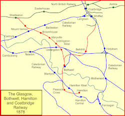
The station was opened by the North British Railway to serve the Broomhouse area in 1883[1] on the Glasgow, Bothwell, Hamilton and Coatbridge Railway route.[4]
The route was also known as the London and North Eastern Railway's Hamilton Branch. It closed to passenger traffic on 4 October 1927 and to freight in 1953,[3] having been previously closed to passengers between 1917 and 1919 as a wartime economy.[1] The line was closed to freight traffic on 4 October 1964.[4][3] Passenger trains continued to run to Bothwell until 4 July 1955.
Infrastructure[]
A signal box that controlled the colliery line lay at the south end of the station on the north side, replaced in 1914 and closed in 1960.[5] Daldowie and Broomhouse collieries lay nearby to the north and south respectively,[6] and crossovers on the double-track line in the area of the station allowed for the movement of waggons for these customers.[3] There was a siding to a brickworks.[6] The ticket office and waiting room were on the south platform, and a shelter on the north and a pedestrian footbridge were present.[7][8]
The line to the west cut over the Caledonian Railway's Rutherglen and Coatbridge Railway line.[8]
Remains on site[]
A road now runs across the old station site.
| Preceding station | Disused railways | Following station | ||
|---|---|---|---|---|
| Calderpark | North British Railway Glasgow, Bothwell, Hamilton and Coatbridge Railway |
Mount Vernon (NBR) |
References[]
Notes[]
- ^ Jump up to: a b c d e f Butt (1995), page 46
- ^ Jump up to: a b Wignal (1983), Page 10
- ^ Jump up to: a b c d e RailScot Broomhouse
- ^ Jump up to: a b RAILSCOT on Glasgow, Bothwell, Hamilton and Coatbridge Railway
- ^ NS66SE - A (includes: Blantyre; Bothwell; Cambuslang; Glasgow; Old Monkland) Surveyed / Revised:1930 to 1957. Published:1958
- ^ Jump up to: a b Broomhouse Community Council
- ^ Lanarkshire Sheet VII.SW (includes: Glasgow; Old Monkland) Publication date:1899. Date revised: 1897.
- ^ Jump up to: a b Lanarkshire VII.14 (Bothwell; Glasgow; Old Monkland) Publication date:1913. Revised:1910. Levelled:1910
Sources[]
- Butt, R. V. J. (1995). The Directory of Railway Stations: details every public and private passenger station, halt, platform and stopping place, past and present (1st ed.). Sparkford: Patrick Stephens Ltd. ISBN 978-1-85260-508-7. OCLC 60251199.
- Jowett, Alan (March 1989). Jowett's Railway Atlas of Great Britain and Ireland: From Pre-Grouping to the Present Day (1st ed.). Sparkford: Patrick Stephens Ltd. ISBN 978-1-85260-086-0. OCLC 22311137.
- "RAILSCOT on Glasgow, Bothwell, Hamilton and Coatbridge Railway". Retrieved 4 September 2011.
This Glasgow railway station-related article is a stub. You can help Wikipedia by . |
- Disused railway stations in Glasgow
- Railway stations in Great Britain opened in 1883
- Railway stations in Great Britain closed in 1917
- Railway stations in Great Britain opened in 1919
- Railway stations in Great Britain closed in 1927
- Former North British Railway stations
- Glasgow railway station stubs