Brougham Place, North Adelaide
Brougham Place | |
|---|---|
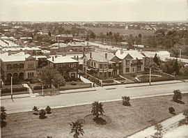 | |
Eastern end in 1910 | |
 | |
| General information | |
| Type | Street |
| Location | North Adelaide |
| Maintained by | City of Adelaide |
| Ring road around | Brougham Gardens |


Brougham Place is a street lined with large mansions set in landscaped grounds in the Adelaide suburb of North Adelaide, South Australia. It surrounds Brougham Gardens, (Park 29 of the Adelaide Park Lands), that joins the three grids that comprise North Adelaide. It was named after Henry Brougham, 1st Baron Brougham and Vaux. He was a staunch supporter of the 1832 Reform Act and the passing of this Act led to the third and successful attempt to found a colony in SA in 1834.[1]
Brougham Place starts and finishes at its intersection with LeFevre Terrace and Stanley Street and runs anti-clockwise around Brougham Gardens.[2] Like other streets in the City of Adelaide with properties only along one side, numbering is sequential from 1 to 228.
Institutions and heritage listed buildings along Brougham Place include [3]
| Number | Name | Heritage listing | Notes |
|---|---|---|---|
| LeFevre Terrace | |||
| 1 | |||
| 5-7 | Private dwelling. Built in 1907 for Sir Charles Henry Goode | State - File No. 13537 | [4] |
| 9 | Taylor House (private dwelling) | State - File No.15536 | [5] |
| 24 | St. Margarets | National | |
| 32 | Former Baker family dwelling, now the Federation House of Lincoln College | State | |
| 35-37 | Former dwelling now part of Lincoln College | State | |
| 39 | Former Rymill family dwelling now the Whitehead Building of Lincoln College | State - File No.13611 | [6] |
| 45 | Former Milne family dwelling now the Administration Building of Lincoln College | State - File No.13610 | [7] |
| 49 | Brougham House (private dwelling) | State | |
| 58 | |||
| King William Road / O'Connell Street | |||
| 62 | Site of the former Hotel Australia | ||
| 71-74 | Belmont, former Masonic Hall | National | |
| 75-78 | Kingsmead House (private dwelling) | National | |
| 80 | South Australian office of the Australian Medical Association | ||
| Palmer Place | |||
| 82 | |||
| 126 | |||
| King William Road | |||
| 137-160 | Women's and Children's Hospital | ||
| Sir Edwin Smith Avenue / Melbourne Street | |||
| 187-191 | St. Ann's College | Local | |
| 193 | Brougham Place Uniting Church, formerly North Adelaide Congregational Church | National | |
| 210 | Former hall of North Adelaide Congregational Church (private dwelling) | State | |
| 222 | Private dwelling | National | |
| 225 | Private dwelling | State | |
Brougham Court[]
Brougham Court (formerly Bower Street) is located off Brougham Place between 95 and 96. It contains the national heritage Ebenezer Baptist Chapel, built in 1843 at 21-29, now a private dwelling [8]
See also[]
![]() Australian Roads portal
Australian Roads portal
References[]
- ^ "History of Adelaide Through Street Names". Archived from the original on 14 June 2008. Retrieved 10 May 2007.
- ^ 2003 Adelaide Street Directory, 41st Edition. UBD (A Division of Universal Press Pty Ltd). 2003. ISBN 0-7319-1441-4.
- ^ Adelaide (City) Development Plan (PDF). Archived from the original (PDF) on 30 August 2007. Retrieved 10 May 2007.
- ^ Former dwelling of Charles Goode, 5-7 Brougham Place, North Adelaide, Adelaide Federation Heritage
- ^ Taylor House, 9 Brougham Terrace, North Adelaide, Adelaide Federation Heritage
- ^ Rymill House, 39 Brougham Place, North Adelaide, Adelaide Federation Heritage
- ^ Milne dwelling, 45 Brougham Place North Adelaide, Adelaide Federation Heritage
- ^ "North Adelaide Baptist Church". Archived from the original on 29 June 2007.
Coordinates: 34°54′35″S 138°35′57″E / 34.90986°S 138.59910°E

- Streets in Adelaide
- North Adelaide