Brown Peak (Sturge Island)
| Brown Peak | |
|---|---|
 Brown Peak | |
| Highest point | |
| Elevation | 1,705 m (5,594 ft)[1] |
| Prominence | 1,705 m (5,594 ft)[1] |
| Listing | Ultra |
| Coordinates | 67°41′S 164°58′E / 67.683°S 164.967°ECoordinates: 67°41′S 164°58′E / 67.683°S 164.967°E[1] |
| Geography | |
| Location | Sturge Island, Balleny Islands, East Antarctica |
| Geology | |
| Mountain type | Stratovolcano |
| Last eruption | 2001[2] |

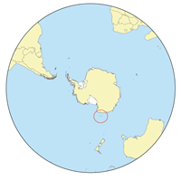
Location of the Balleny Islands
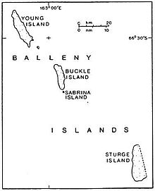
Sturge Island is the southernmost of the Balleny Islands
Brown Peak is a stratovolcano and the highest point of the Balleny Islands. It is situated on the northern part of Sturge Island.
Discovery and naming[]
John Balleny discovered Brown Peak in February 1839, and named it for W. Brown, a merchant who provided financial support to the Enderby Brothers' expedition. In 1841, Captain James Clark Ross, who sighted the islands on his own expedition to Antarctica, gave it the name Russell Peak.[1]
Possible 2001 eruption[]
Satellite imagery suggests that an eruption may have occurred on or about 12 June 2001.[3]
See also[]
References[]
- ^ a b c d "Brown Peak". Geographic Names Information System. United States Geological Survey. Retrieved 14 March 2010.
- ^ "Sturge Island". Global Volcanism Program. Smithsonian Institution. Retrieved 21 January 2018.
- ^ "Report on Sturge Island (Antarctica) — May 2001". Bulletin of the Global Volcanism Network. Smithsonian Institution. Museum of Natural History. Global Volcanism Program. 26 (5). May 2001. doi:10.5479/si.GVP.BGVN200105-390012.
Bibliography[]
- LeMasurier, W. E.; Thomson, J. W., eds. (1990). Volcanoes of the Antarctic Plate and Southern Oceans. American Geophysical Union. pp. 512 pp. ISBN 0-87590-172-7.
External links[]
- "Brown Peak (New Zealand)". Composite Gazetteer of Antarctica. Scientific Committee on Antarctic Research.
- "Brown Peak (United States)". Composite Gazetteer of Antarctica. Scientific Committee on Antarctic Research.
This article about the geography of New Zealand's outlying islands is a stub. You can help Wikipedia by . |
Categories:
- Volcanoes of the Balleny Islands
- Mountains of New Zealand
- Stratovolcanoes of New Zealand
- New Zealand outlying island geography stubs