Brushes Reservoir
| Brushes Reservoir | |
|---|---|
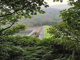 Brushes Reservoir and dam | |
 Brushes Reservoir | |
| Location | Greater Manchester |
| Coordinates | 53°29′19″N 2°00′42″W / 53.4887°N 2.0116°WCoordinates: 53°29′19″N 2°00′42″W / 53.4887°N 2.0116°W |
| Type | reservoir |
| Max. depth | 44 ft (13 m) |
| Water volume | 52,165,000 US gal (197,470,000 l; 43,436,000 imp gal) |

Brushes Reservoir is the second lowest reservoir of a series of four in the Brushes valley above Stalybridge in Greater Manchester.[1] It was built in the 19th century to provide a supply of safe drinking water. It is owned and operated by United Utilities. The reservoir dam consists of a clay core within an earth embankment.
Capacity[]
| Name | Depths of Reservoirs | Capacities of Reservoirs |
|---|---|---|
| Walkerwood Reservoir | 61 ft (19 m) | 202,084,000 US gal (764,970,000 l; 168,270,000 imp gal) |
| Brushes | 44 ft (13 m) | 52,165,000 US gal (197,470,000 l; 43,436,000 imp gal) |
| Lower Swineshaw Reservoir | 33 ft (10 m) | 55,500,000 US gal (210,000,000 l; 46,200,000 imp gal) |
| Higher Swineshaw Reservoir | 53 ft (16 m) | 168,908,000 US gal (639,390,000 l; 140,645,000 imp gal) |
| *Total | - | 882,939,000 US gal (3.34229×10⁹ l; 735,201,000 imp gal) [2] |
See also[]
References[]
- ^ "Seven of the best places to enjoy a reservoir walk". Manchester Evening News. M.E.N. Media. Retrieved 3 December 2016.
- ^ "Ashton under Lyne Genealogical Records". Forebears. Section:Historical description: Forebears. Retrieved 3 December 2016.
This article about a Greater Manchester building or structure is a stub. You can help Wikipedia by . |
Categories:
- Reservoirs in Greater Manchester
- Greater Manchester building and structure stubs