Buck Island (British Virgin Islands)
 Buck Island, British Virgin Islands | |
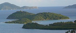
 Buck Island The location of Buck Island within the British Virgin Islands | |
| Geography | |
|---|---|
| Location | Caribbean Sea |
| Coordinates | 18°25′26″N 64°33′29″W / 18.424°N 64.558°WCoordinates: 18°25′26″N 64°33′29″W / 18.424°N 64.558°W |
| Archipelago | Virgin Islands |
| Administration | |
| British Overseas Territory | British Virgin Islands |
| Additional information | |
| Time zone |
|
| ISO code | VG |


Buck Island is a privately owned island of the British Virgin Islands in the Caribbean.
Overview[]
A former owner had begun to build a bridge between Buck Island and the mainland of Tortola, but construction ceased when it was discovered that under British Virgin Islands law that would create a right in favour of the general public to cross the bridge and use the island's beaches. Accordingly, he stopped and the bridge was never completed.
The island also has an obsolete airstrip on it, which is now in ruins.
Curiously, in the adjacent United States Virgin Islands there are two other islets which go by the name "Buck Island" - Buck Island Reef National Monument near St. Croix and Buck Island National Wildlife Refuge near St. Thomas.
It is 43 acres and it has swimming-pools.[1] As of 2012, it is the world's second most expensive private island.[1]
In 2017 the island was advertised for sale on the real estate website Rightmove[2] at US$30,000,000.
References[]
External links[]
![]() Media related to Buck Island (British Virgin Islands) at Wikimedia Commons
Media related to Buck Island (British Virgin Islands) at Wikimedia Commons
This British Virgin Islands location article is a stub. You can help Wikipedia by . |
- Private islands of the British Virgin Islands
- British Virgin Islands geography stubs