Bullet Tree Falls
Bullet Tree Falls | |
|---|---|
 Aerial view of the main road in Bullet Tree Falls | |
 Bullet Tree Falls | |
| Coordinates: 17°10′05″N 89°06′40″W / 17.168°N 89.111°WCoordinates: 17°10′05″N 89°06′40″W / 17.168°N 89.111°W | |
| Country | |
| District | Cayo District |
| Constituency | Cayo North |
| Elevation | 69 m (226 ft) |
| Population (2010) | |
| • Total | 2,124[1] |
| Time zone | UTC-6 (Central) |
| Climate | Am |

Bullet Tree Falls is a village located along the Mopan River in Cayo District, Belize. It lies approximately five kilometers (three miles) northwest of San Ignacio.[2][3] According to the 2010 census, Bullet Tree Falls has a population of 2,124 people in 426 households.[1] The population consists mainly of Spanish-speaking mestizos, along with a smaller number of Yucatec Maya and Creoles.[2][3][4]

Government[]
Bullet Tree Falls is governed by a seven-person village council. As of 2019, the chairperson of the council is Sabino Pinelo.[5]
History[]
Bullet Tree Falls was originally settled by loggers, and by the late 1800s had attracted a small number of Maya families.[2] After the Caste War of Yucatán numerous Maya refugees from the north settled in the area.[2] During the early 20th century, an influx of mestizos migrated to the village from Guatemala and Mexico.[4] The first Creoles settled in Bullet Tree Falls in the 1950s, arriving from San Ignacio.[6]
During the early days of the chicle and timber industries in Belize, the village was an important trading post.[7] In 1961, Hurricane Hattie caused significant damage to the village, destroying a school building and church.[8] In 1988, the Salvador Fernandez Bridge was completed, replacing an older wooden bridge.[8]
Attractions[]

Bullet Tree Falls has developed a small tourist economy facilitated by its location between San Ignacio and the El Pilar Maya archeological site.[2] The village hosts several lodges and a small botanical garden.[9] Buses between Bullet Tree Falls and San Ignacio run several times a day and taxi service is available to San Ignacio and El Pilar.[9]
Gallery[]

The Community Center

The main bus stop

Aerial view of the village
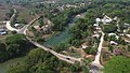
The Salvador Fernandez Bridge and Mopan River


References[]
- ^ a b "Belize Population and Housing Census: 2010 Country Report" (PDF). Statistical Institute of Belize. Archived from the original (PDF) on 27 January 2016. Retrieved 25 July 2015.
- ^ a b c d e Pridgeon, Elizabeth (19 February 2010). "Bullet Tree Falls". The Belize Times. Archived from the original on 26 May 2011.
- ^ a b Eltringham, Peter; Fisher, John; Stewart, Iain (2001). The Rough Guide to the Maya World: Guatemala, Belize, Southern Mexico, Honduras, El Salvador. London: Rough Guides. p. 269. ISBN 1858287421.
- ^ a b Gordon, Andrew (28 February 2020). "Rastafarianism in Bullet Tree Falls, Belize: Exploring the Effects of International Trends". Societies. 10 (1): 1–16. doi:10.3390/soc10010024.
- ^ "Village Council Election Results: Bullet Tree, Cayo District" (PDF). Elections and Boundaries Department, Government of Belize. July 29, 2019. Retrieved September 25, 2019.
- ^ Gordon, Andrew J. (2016). Agents of Change in Bullet Tree Falls: How a Village in Belize Responded to Influences of Globalization. Wadsworth Publishing. p. 10. ISBN 1133604498.
- ^ Silva, Hector David (July 2010). Brief History of the Cayo District. SEYT. p. 74.
- ^ a b "History of Immaculate Conception R. C. School". Immaculate Conception Roman Catholic School. Archived from the original on 2 June 2013.
- ^ a b c Vorhees, Mara (2008). Lonely Planet Belize: Cayo District. Lonely Planet. ASIN B002RI96MG.
External links[]
| Wikimedia Commons has media related to Bullet Tree Falls. |
- Bullet Tree Falls at Belize LocalWiki
- Map of Bullet Tree Falls at OpenStreetMap
- Populated places in Cayo District
- Cayo North