Burnside Street
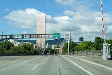 Facing west on the Burnside Bridge | |||
| Former name(s) |
| ||
|---|---|---|---|
| Owner |
Portland Bureau of Transportation west of the east 16100 block; City of Gresham east of east 16100 to Mt. Hood Hwy | ||
| Length | 17.6 mi[1] (28.3 km) | ||
| Location | Portland and Gresham, Oregon, U.S. | ||
| From | Mount Hood Highway | ||
| To | SW Barnes Road | ||
Burnside Street is a major thoroughfare of Portland, in the U.S. state of Oregon, and one of a few east–west streets that run uninterrupted on both sides of the Willamette River. It serves as the dividing line between North Portland and South Portland. Its namesake bridge, Burnside Bridge, is one of the most heavily traversed in Portland. In Gresham between approximately the east 18300 block to Mt. Hood Hwy (and E Powell Blvd/SE Powell Valley Rd), Burnside runs southeast–northwest and is no longer the divide between northeast and southeast on the City of Portland-Multnomah County street grid. Additionally (as you travel southeast), SE Burnside St becomes NW Burnside Road at SE 202nd/NW Birdsdale Ave, and NE Burnside Rd at N Main Ave in Gresham. Burnside Road's eastern terminus is where it meets Mt. Hood Hwy (US-26), E Powell Blvd (US-26), and SE Powell Valley Road.
History[]

What is now Burnside Street was originally named B Street east of Southwest 16th Avenue and Washington Street west of S.W. 16th (as a continuation of Washington Street from downtown). In 1891, B Street was renamed for Portland merchant David Burnside, and in 1933 Washington Street west of SW 16th was renamed Burnside Street.[2][3] Burnside became Portland's principal east–west axis following the 1912 Bennett Plan, soon becoming one of the widest streets in the city.[3] The street runs from SW Barnes Road in Sylvan-Highlands to the Mount Hood Highway in Gresham, a distance of over 17 miles (27 km). It crosses the Willamette River via the Burnside Bridge, where the White Stag sign is visible.
For a number of years, the portion of Burnside between NW 19th Avenue and NE Sandy Boulevard was designated U.S. Route 30. It is served by TriMet bus line 20 between Barnes Road and NE/SE 102nd Avenue, and several MAX Blue Line light-rail stations are located along its route in East Portland between 102nd Avenue and Ruby Junction.[4]
See also[]
References[]
- ^ "Burnside Road". Google Maps. Retrieved January 22, 2016.
- ^ Snyder, Eugene (1979). Portland Names and Neighborhoods: Their Historic Origins. pp. 102–104. ISBN 083230347X.
In the renaming of 1891, "B Street" was made a namesake for David W. Burnside
- ^ a b "Burnside Street History". City of Portland. Retrieved January 26, 2016.
- ^ "Route 20-Burnside/Stark". TriMet.
External links[]
| Wikimedia Commons has media related to Burnside Street. |
This Oregon road or road transport-related article is a stub. You can help Wikipedia by . |
- Streets in Portland, Oregon
- Western United States road stubs
- Oregon transportation stubs