Byrd Glacier
| Byrd Glacier | |
|---|---|
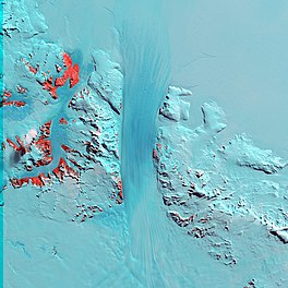 Byrd Glacier from Landsat | |
 Location of Byrd Glacier in Antarctica | |
| Location | Ross Dependency |
| Coordinates |  80°20′S 159°00′E / 80.333°S 159.000°E / -80.333; 159.000 80°20′S 159°00′E / 80.333°S 159.000°E / -80.333; 159.000 |
| Length | 136 km (85 mi) |
| Width | 24 km (15 mi) |
| Thickness | unknown |
| Terminus | Ross Ice Shelf |
| Status | unknown |
The Byrd Glacier is a major glacier in Antarctica, about 136 km (85 mi) long and 24 km (15 mi) wide, draining an extensive area of the polar plateau and flowing eastward between the Britannia Range and Churchill Mountains to discharge into the Ross Ice Shelf at Barne Inlet. Its valley below the glacier used to be recognised as one of the lowest point not to be covered by water on Earth (assuming ice doesn't count as water), reaching 2,780 metres (9,120 feet) below sea level.[1] It was named by the NZ-APC after Rear Admiral Byrd, US Navy Antarctic explorer.
On the south side of Byrd Glacier is Blake Massif.[2]
See also[]
- Glaciology
- Ice stream
- List of Antarctic ice streams
- List of glaciers in the Antarctic
- List of places in Antarctica below sea level
- Denman Glacier
References[]
- ^ "About - British Antarctic Survey". www.bas.ac.uk. Archived from the original on 26 September 2015. Retrieved 30 April 2018.
- ^ "Antarctica Detail: Blake Massif". geonames.usgs.gov. United States Geological Survey. Retrieved 12 January 2019.

 Geography portal
show
Glaciers | |||||||
|---|---|---|---|---|---|---|---|
| Types |
| ||||||
| Anatomy |
| ||||||
| Processes |
| ||||||
| Measurements |
| ||||||
| Volcanic relations | |||||||
| Landforms |
| ||||||
| |||||||
show
Glaciers in the Antarctic | |
|---|---|
|
show
Glaciers of the Ross Dependency | |
|---|---|
| King Edward VII Land |
|
| Ross Dependency |
|
| show Authority control | |
|---|---|
| General |
|
| National libraries | |
This article about a glacier in the Ross Dependency is a stub. You can help Wikipedia by . |
- v
- t
This article about a glacier in Oates Land is a stub. You can help Wikipedia by . |
- v
- t
- Ice streams of Antarctica
- Glaciers of Oates Land
- Glaciers of Hillary Coast
- Ross Dependency glacier stubs
- Oates Land glacier stubs
- Articles with VIAF identifiers
- Articles with LCCN identifiers
- Articles with WorldCat-VIAF identifiers
- All stub articles