C Line (RTD)
This article needs additional citations for verification. (December 2009) |
| C Line | ||||||||||||||||||||||||||||||||||||||||||||||||||||||||||||||||||||||||||||||||||||||||||||||||||||||||||||||||||||||||||||||||||||||||||||||||||||||||||||||||||||||||||||||||||||
|---|---|---|---|---|---|---|---|---|---|---|---|---|---|---|---|---|---|---|---|---|---|---|---|---|---|---|---|---|---|---|---|---|---|---|---|---|---|---|---|---|---|---|---|---|---|---|---|---|---|---|---|---|---|---|---|---|---|---|---|---|---|---|---|---|---|---|---|---|---|---|---|---|---|---|---|---|---|---|---|---|---|---|---|---|---|---|---|---|---|---|---|---|---|---|---|---|---|---|---|---|---|---|---|---|---|---|---|---|---|---|---|---|---|---|---|---|---|---|---|---|---|---|---|---|---|---|---|---|---|---|---|---|---|---|---|---|---|---|---|---|---|---|---|---|---|---|---|---|---|---|---|---|---|---|---|---|---|---|---|---|---|---|---|---|---|---|---|---|---|---|---|---|---|---|---|---|---|---|---|---|
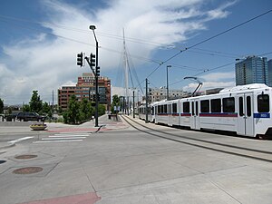 Old alignment near Union Station | ||||||||||||||||||||||||||||||||||||||||||||||||||||||||||||||||||||||||||||||||||||||||||||||||||||||||||||||||||||||||||||||||||||||||||||||||||||||||||||||||||||||||||||||||||||
| Overview | ||||||||||||||||||||||||||||||||||||||||||||||||||||||||||||||||||||||||||||||||||||||||||||||||||||||||||||||||||||||||||||||||||||||||||||||||||||||||||||||||||||||||||||||||||||
| Status | Suspended | |||||||||||||||||||||||||||||||||||||||||||||||||||||||||||||||||||||||||||||||||||||||||||||||||||||||||||||||||||||||||||||||||||||||||||||||||||||||||||||||||||||||||||||||||||
| Owner | Regional Transportation District | |||||||||||||||||||||||||||||||||||||||||||||||||||||||||||||||||||||||||||||||||||||||||||||||||||||||||||||||||||||||||||||||||||||||||||||||||||||||||||||||||||||||||||||||||||
| Locale | Denver-Aurora Metropolitan Area | |||||||||||||||||||||||||||||||||||||||||||||||||||||||||||||||||||||||||||||||||||||||||||||||||||||||||||||||||||||||||||||||||||||||||||||||||||||||||||||||||||||||||||||||||||
| Termini | Union Station Littleton–Mineral | |||||||||||||||||||||||||||||||||||||||||||||||||||||||||||||||||||||||||||||||||||||||||||||||||||||||||||||||||||||||||||||||||||||||||||||||||||||||||||||||||||||||||||||||||||
| Stations | 12 | |||||||||||||||||||||||||||||||||||||||||||||||||||||||||||||||||||||||||||||||||||||||||||||||||||||||||||||||||||||||||||||||||||||||||||||||||||||||||||||||||||||||||||||||||||
| Service | ||||||||||||||||||||||||||||||||||||||||||||||||||||||||||||||||||||||||||||||||||||||||||||||||||||||||||||||||||||||||||||||||||||||||||||||||||||||||||||||||||||||||||||||||||||
| Type | Light Rail | |||||||||||||||||||||||||||||||||||||||||||||||||||||||||||||||||||||||||||||||||||||||||||||||||||||||||||||||||||||||||||||||||||||||||||||||||||||||||||||||||||||||||||||||||||
| System | Regional Transportation District | |||||||||||||||||||||||||||||||||||||||||||||||||||||||||||||||||||||||||||||||||||||||||||||||||||||||||||||||||||||||||||||||||||||||||||||||||||||||||||||||||||||||||||||||||||
| Operator(s) | Regional Transportation District | |||||||||||||||||||||||||||||||||||||||||||||||||||||||||||||||||||||||||||||||||||||||||||||||||||||||||||||||||||||||||||||||||||||||||||||||||||||||||||||||||||||||||||||||||||
| History | ||||||||||||||||||||||||||||||||||||||||||||||||||||||||||||||||||||||||||||||||||||||||||||||||||||||||||||||||||||||||||||||||||||||||||||||||||||||||||||||||||||||||||||||||||||
| Opened | April 5, 2002 | |||||||||||||||||||||||||||||||||||||||||||||||||||||||||||||||||||||||||||||||||||||||||||||||||||||||||||||||||||||||||||||||||||||||||||||||||||||||||||||||||||||||||||||||||||
| Technical | ||||||||||||||||||||||||||||||||||||||||||||||||||||||||||||||||||||||||||||||||||||||||||||||||||||||||||||||||||||||||||||||||||||||||||||||||||||||||||||||||||||||||||||||||||||
| Track gauge | 4 ft 8+1⁄2 in (1,435 mm) | |||||||||||||||||||||||||||||||||||||||||||||||||||||||||||||||||||||||||||||||||||||||||||||||||||||||||||||||||||||||||||||||||||||||||||||||||||||||||||||||||||||||||||||||||||
| Electrification | Overhead lines, 750 V DC | |||||||||||||||||||||||||||||||||||||||||||||||||||||||||||||||||||||||||||||||||||||||||||||||||||||||||||||||||||||||||||||||||||||||||||||||||||||||||||||||||||||||||||||||||||
| ||||||||||||||||||||||||||||||||||||||||||||||||||||||||||||||||||||||||||||||||||||||||||||||||||||||||||||||||||||||||||||||||||||||||||||||||||||||||||||||||||||||||||||||||||||
The C Line is a light rail line which was part of the rail system operated by the Regional Transportation District in the Denver-Aurora Metropolitan Area in Colorado. The line was added to the system on April 5, 2002, to coincide with the opening of the Central Platte Valley Spur. Initially, C trains operated seven days a week, but ran to Mineral Ave. only during peak hours and sporting events. At all other times, C service operated to I-25/Broadway. On May 3, 2003, C trains began operating to Mineral Ave. at all times. With the opening of the Southeast Corridor on November 17, 2006, weekend C service was discontinued except for certain sporting events, with the new E line operating seven days per week. On January 11, 2009, the midday service pattern between Union Station and I-25/Broadway was resumed and evening service discontinued. Midday weekday service was discontinued on January 19, 2012 and was reinstated on August 17, 2014 over the entire route. The C Line was fully suspended on January 10, 2021 as part of broader service cuts in response to ridership decreases related to the COVID-19 pandemic.[1]
Stations[]
The C Line's northern terminus was at Union Station in Denver, ran on a railroad right-of-way south to its junction with the D Line at 10th & Osage Station, and shared track with the D Line until both lines reach their southern terminus at Mineral Avenue in Littleton.[2]
In addition, the C Line provided access to the sports venues of Denver – Coors Field, Pepsi Center, and Broncos Stadium at Mile High – Six Flags Elitch Gardens, and LoDo, as well as access to the western portion of the Auraria Campus.
| Fare zone |
Municipality | Station | Opening year |
Interchange | Park & Ride |
|---|---|---|---|---|---|
| A | Denver | Union Station | 2002 | No | |
| Ball Arena–Elitch Gardens | 2002 | No | |||
| Empower Field at Mile High | 2002 | No | |||
| Auraria West | 2002 | No | |||
| 10th & Osage | 1994 | No | |||
| Alameda | 1994 | No | |||
| I-25 & Broadway | 1994 | Yes | |||
| B | Evans | 2000 | Yes | ||
| Englewood | Englewood | 2000 | Yes | ||
| Sheridan | Oxford–City of Sheridan | 2000 | No | ||
| C | Littleton | Littleton–Downtown | 2000 | Yes | |
| Littleton–Mineral | 2000 | Yes |
FasTracks[]
The 2004 voter approved FasTracks plan will add 2.5 mi (4.02 km) to the Southwest Corridor (C Line and D Line). It will also add a station with 1,000 parking spots at C-470 and Lucent Boulevard in Highlands Ranch. There may also be a station at C-470 and Santa Fe Boulevard.[3]
References[]
- ^ Richards, Makayla. "RTD service changes take effect Sunday". 9News. 10 January 2021. Retrieved 6 June 2021.
- ^ "RTD - Light Rail System Map". Regional Transportation District. Retrieved June 2, 2014.
- ^ "Fastracks - Southwest Corridor". Regional Transportation District. Retrieved April 11, 2010.
External links[]
Route map:

| ( • help)
|
| Operators |
| ||||||||||
|---|---|---|---|---|---|---|---|---|---|---|---|
| Rail service |
| ||||||||||
| Bus service | |||||||||||
| Other topics | |||||||||||
- RTD light rail
- Transportation in Arapahoe County, Colorado
- 750 V DC railway electrification
- Railway lines opened in 2002