Cabauw
Cabauw | |
|---|---|
Village | |
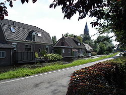 Cabauw, with St. Jacob's church in the background | |
 | |
 The village centre (dark green) and the statistical district (light green) of Cabauw in the municipality of Lopik. | |
| Coordinates: 51°57′52″N 4°53′54″E / 51.96444°N 4.89833°ECoordinates: 51°57′52″N 4°53′54″E / 51.96444°N 4.89833°E | |
| Country | Netherlands |
| Province | Utrecht (province) |
| Municipality | Lopik |
| Population (2018) | |
| • Total | 730 |
| Time zone | UTC+1 (CET) |
| • Summer (DST) | UTC+2 (CEST) |

Cabauw is a village in the Dutch province of Utrecht. It is part of the municipality of Lopik, and lies about 12 km southwest of IJsselstein. Cabauw consists of a small village centre, and a ribbon of farms along the Lopikerwetering canal, between Zevender and Lopik.
In 2008, the village centre of Cabauw had 310 inhabitants. The built-up area of the village was 0.05 km², and contained 123 residences.[1] The statistical district Cabauw, covering the village centre and the farms along the canal, has a population of around 690.[2]
Cabauw used to be a separate municipality. In 1857, it became a part of the municipality of Willige Langerak, which in its turn was merged into Lopik in 1943. Cabauw is and has long been a catholic enclave within a predominantly Protestant region.
References[]
This Utrecht location article is a stub. You can help Wikipedia by . |
- Populated places in Utrecht (province)
- Former municipalities of Utrecht (province)
- Lopik
- Utrecht (province) geography stubs