Cabo de Rama
This article does not cite any sources. (October 2013) |
| Cabo de Rama Fort | |
|---|---|
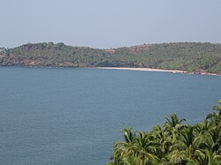 View from Cabo de Rama fort | |
| Location | Canacona, Goa |
| Coordinates | 15°05′17″N 73°55′12″E / 15.08806°N 73.91991°ECoordinates: 15°05′17″N 73°55′12″E / 15.08806°N 73.91991°E |
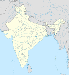 Location in Goa, India | |

Praça do Cabo de Rama is a medieval hillfort on the coast of Canacona, Goa.
History[]
In the 1760s, the Portuguese gained control of Cabo de Rama after the Raja of Soonda surrendered his territory to them in return for protection against Hyder Ali of Mysore. Prior to that, the fort had regularly switched hands between Hindu and Muslim monarchs. The present structure with its walls, moats, ramparts turrets, chapel and cannons are remnants of the Portuguese era. The Portuguese equipped it with 21 guns and installed military barracks, a commander's quarter and a chapel.
In 1799, the Fourth Anglo-Mysore War saw the defeat of the King of Mysore, thus bringing an end to the Portuguese's primary rival in the region. Over time, the purpose of the fort shifted from being a defensive structure, to a prison. This fort housed a government prison till 1955.
Today, this fort is in partial ruins, but is a popular tourist attraction of Goa.
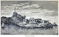
A view from 1886

Entrance of the Cabo de Rama Fort


Chapel of Saint Anthony[]
Inside Cabo de Rama, there is the Capela de Santo António which is in excellent condition and is still used by devotees. The white church and the red-stone fort provide a photographic picture of stark contrast. People come here to pray and just enjoy the mystical atmosphere of the fort. Cliffs drop steeply to the sea provide a panoramic outlook of the surrounding areas, at the western side of the fortress. The fort provides majestic views of the entire length of Colva beach and the Canacona stretch.
External links[]
- http://www.goavacationguide.com/cabo-fort.html
- https://bluestoneholiday.com/cabo-de-rama-fort-in-goa/
- Cabo de Rama stunning pictures and spherical panoramas 360°
- Cabo de Rama Fort and beach [1]
| Authority control |
|
|---|
- Forts in Goa