Cala Pada
| Cala Pada | |
|---|---|
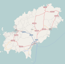 Location of Cala Pada on Ibiza | |
| Location | Santa Eulària des Riu, Ibiza, Spain |
| Coordinates | 38°59′14″N 1°34′24″E / 38.98722°N 1.57333°ECoordinates: 38°59′14″N 1°34′24″E / 38.98722°N 1.57333°E |
| Geology | Beach |

Cala Pada is a beach on the south east seaboard of the Spanish island of Ibiza. It is in the municipality of Santa Eulària des Riu[1] and is 2.7 miles (4.3 km)[2] east of the town of Santa Eulària des Riu, and 1.9 miles (3.1 km) south west of the beach resort of Es Canar.[2]
Description[]
Cala Pada beach is a broad sandy stretch of beach backed by a wood of pine and juniper trees.[3] The offshore reefs protect the bay from the sea, making it popular with the island's windsurfers when the south wind blows.[3] From the beach there are views to several small offshore islands including Illa de Santa Eulària, Illa Rodona and En Caragoler.
Illa Rodona[]
On 17 January 1913.[4] a steamship called the SS Mallorca ran aground on a reef around Illa Rodona. The crew and passengers were rescued from the ship by the local fishermen of Santa Eulària des Riu. There is a stone memorial to commemorate the rescue in front of the Ajuntament (town hall) in the plaçe d' Espanya, Santa Eulària des Riu.
External links[]
- for SS Mallorca Shipwreck details
Gallery[]

The SS Mallorca which sank on 17 January 1913 after running aground on a reef around Illa Rodona

References[]
- ^ Mapa Topografico Nacional de Espana, Santa Eulària des Riu 1:50.000. Published: IGN - CNIG (Spain Civilian Survey): 2006. ISBN 978-84-416-0041-6
- ^ a b "579 Regional Map, Spain, Islas Baleares. Pub:Michelin Editions des Voyages, 2004, ISBN 2-06-710098-X
- ^ a b The Rough Guide to Ibiza & Formentera. Pub:Rough Guides, Penguin Group, 2003, ISBN 1-84353-063-5
- ^ The Life and Death of a Spanish Town: Author: Elliot Paul Publisher: London : Peter Davis; Publisher USA; Random House, New York;1st Edition (1937) ASIN B002DQL7GK
- Beaches of Ibiza
- Beaches of the Balearic Islands