Calabasas, California
Calabasas, California | |
|---|---|
City | |
| City of Calabasas | |
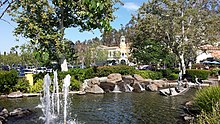
    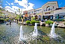 Clockwise: Aerial view of Calabasas looking northwest; Leonis Adobe; The Commons at Calabasas; Mulholland Highway; The Commons | |
|
| |
 Location of Calabasas in Los Angeles County, California | |
 Calabasas Location in Los Angeles metropolitan area | |
| Coordinates: 34°8′18″N 118°39′39″W / 34.13833°N 118.66083°WCoordinates: 34°8′18″N 118°39′39″W / 34.13833°N 118.66083°W | |
| Country | |
| State | |
| County | |
| Incorporated | April 5, 1991[1] |
| Named for | Spanish for "pumpkin", "squash", or "gourd" |
| Government | |
| • Type | Council–manager |
| • Mayor | Alicia Weintraub [2] |
| Area | |
| • Total | 13.72 sq mi (35.53 km2) |
| • Land | 13.68 sq mi (35.44 km2) |
| • Water | 0.04 sq mi (0.09 km2) 0.38% |
| Elevation | 928 ft (283 m) |
| Population | |
| • Total | 23,058 |
| • Estimate (2019)[6] | 23,853 |
| • Density | 1,743.39/sq mi (673.14/km2) |
| Time zone | UTC-8 (Pacific) |
| • Summer (DST) | UTC-7 (PDT) |
| ZIP codes | 91301, 91302, 91372[7] |
| Area code | 747 and 818[8] |
| FIPS code | 06-09598 |
| GNIS feature IDs | 239994, 2409955 |
| Website | www |


Calabasas ([ˌkalaˈβasas]) is a city in the northwest Santa Monica Mountains region of Los Angeles County, California. The Leonis Adobe, an adobe structure in Old Town Calabasas, dates from 1844 and is one of the oldest surviving buildings in greater Los Angeles.[9][10] The city was incorporated in 1991, prior to which it was an unincorporated portion of Los Angeles County. As of the 2010 census, the city's population was 23,058, up from 20,033 at the 2000 census.[11]
Naming[]
The name Calabasas is derived from the Spanish calabaza, meaning "pumpkin", "squash", or "gourd"[12] (compare: calabash). Some historians hold the theory that Calabasas is derived from the Chumash word calahoosa, which is said to mean "where the wild geese fly."[13] Owing to vast presence of wild squash plants in the area the squash theory is more prevalent among residents. At the top of the Calabasas grade, which is east of Las Virgenes Road, legend has it that in 1824 a Basque rancher from Oxnard spilled a wagonload of pumpkins on the road en route to Los Angeles. The following spring hundreds of pumpkins sprouted alongside the road. The area was named Las Calabasas—the place where the pumpkins fell.[14]
In honor of its namesake the City of Calabasas and the Calabasas Chamber of Commerce hold a Pumpkin Festival in October, including carnival games, exhibits, demonstrations and live entertainment. The festival has evolved from a small-town fair to a significant annual event. Though the current Pumpkin Festival is held at Juan Bautista de Anza Park in Calabasas, the original festival is believed to have taken place at the site where the wagon carrying pumpkins overturned and produced the area's first pumpkin patch.
The city's official logo depicts a red-tailed hawk flying over the Santa Monica Mountains.
History[]
Centuries ago, Chumash Native Americans lived in the area that is now Calabasas. Spanish explorers were the first Europeans to arrive in the area. In 1770, an expedition headed by Gaspar de Portolá crossed through the area on their return southward to Mexico after venturing into Northern California. In 1776, another party of explorers led by Juan Bautista de Anza camped there on their way northward from Mexico.[15]
Calabasas was the name given to a ranchería in the Los Angeles area in 1795. The Leonis Adobe, an adobe structure in Old Town Calabasas, dates from 1844 and is one of the oldest surviving buildings in greater Los Angeles.[9][10] The city was incorporated on April 5, 1991, making it the newest city in Los Angeles County.[16]
On January 26, 2020, a Sikorsky S-76 crashed in Calabasas after an earlier takeoff from John Wayne Airport. All nine people on board, including Hall of Fame basketball player Kobe Bryant and his 13-year-old daughter Gianna, were killed.[17]
Geography[]
The city is located in the southwest corner of the San Fernando Valley,[18] in Los Angeles County, and comprises a portion of the Santa Monica Mountains. It is 31 miles (50 km) away from downtown Los Angeles. It is bordered by the Woodland Hills neighborhood of Los Angeles to the northeast, Topanga to the east, Malibu to the south, Agoura Hills to the west, and Hidden Hills to the north. The historic El Camino Real runs east–west through Calabasas as the Ventura Freeway (US 101).
According to the United States Census Bureau, the city has a total area of 13.0 square miles (34 km2)—12.9 square miles (33 km2) of it is land and 0.1 square miles (0.26 km2) of it (0.38%) is covered by water.
One of the oldest neighborhoods in Calabasas is Park Moderne, or the "Bird Streets." A former artists' colony, remnants remain of the club house, pool, and cabins scattered across streets with bird names, such as Meadow Lark, Blackbird, Bluebird, and Hummingbird located right behind Calabasas High School.[19]
Climate[]
| hideClimate data for Calabasas, California | |||||||||||||
|---|---|---|---|---|---|---|---|---|---|---|---|---|---|
| Month | Jan | Feb | Mar | Apr | May | Jun | Jul | Aug | Sep | Oct | Nov | Dec | Year |
| Record high °F (°C) | 87 (31) |
86 (30) |
89 (32) |
96 (36) |
98 (37) |
104 (40) |
107 (42) |
101 (38) |
114 (46) |
98 (37) |
93 (34) |
81 (27) |
114 (46) |
| Average high °F (°C) | 69 (21) |
70 (21) |
74 (23) |
77 (25) |
80 (27) |
86 (30) |
92 (33) |
93 (34) |
91 (33) |
84 (29) |
76 (24) |
68 (20) |
80 (27) |
| Average low °F (°C) | 46 (8) |
46 (8) |
49 (9) |
51 (11) |
55 (13) |
60 (16) |
64 (18) |
64 (18) |
62 (17) |
57 (14) |
50 (10) |
44 (7) |
54 (12) |
| Record low °F (°C) | 27 (−3) |
32 (0) |
34 (1) |
37 (3) |
40 (4) |
49 (9) |
51 (11) |
54 (12) |
44 (7) |
43 (6) |
33 (1) |
31 (−1) |
27 (−3) |
| Average precipitation inches (mm) | 3.62 (92) |
4.65 (118) |
2.86 (73) |
1.02 (26) |
0.31 (7.9) |
0.07 (1.8) |
0.02 (0.51) |
0.05 (1.3) |
0.14 (3.6) |
0.93 (24) |
1.34 (34) |
2.76 (70) |
17.77 (451) |
| Source 1: MSN.com[20] | |||||||||||||
| Source 2: WeatherForYou.com[21] | |||||||||||||
Communities[]
From Parkway Calabasas: Hidden Hills West, Calabasas Hills, Calabasas Park Estates, and Park Granada or Mulholland Drive.
From Valley Circle/Mulholland: Mulholland Heights, Mulwood, Las Villas, Bellagio, The Ridge, Creekside, Clairidge, Calabasas Country Estates, Calabasas Highlands, Mountain Park, Abercrombie Ranch Estates,[22] Cold Creek, and Park Moderne.[23]
From Las Virgenes: Mountain View Estates, Monte Nido, Deer Springs, Stone Creek, El Encanto, Mont Calabasas, Malibu Canyon Park, The Colony at Calabasas, and Avalon Calabasas (formerly Archstone Calabasas).
Mont Calabasas, a community on Las Virgenes Road, was annexed into the city of Calabasas in 2011. Prior to annexation, the neighborhood was located in an unincorporated area of Los Angeles County.
From Lost Hills Road: Calabasas View, Saratoga Hills, Saratoga Ranch, Deer Springs, and Steeplechase.
Demographics[]
| Historical population | |||
|---|---|---|---|
| Census | Pop. | %± | |
| 2000 | 20,033 | — | |
| 2010 | 23,058 | 15.1% | |
| 2019 (est.) | 23,853 | [6] | 3.4% |
| U.S. Decennial Census[24] | |||
2010[]
The 2010 United States Census[25] reported Calabasas to have a population of 23,058. The population density was 1,780.4 people per square mile (687.4/km2).
The Census reported that 23,049 people lived in households, 9 lived in non-institutionalized group quarters, and none were institutionalized. Of 8,543 households, 3,320 (38.9%) had children under the age of 18 living at home, 5,124 (60.0%) were opposite-sex married couples living together, 942 (11.0%) had a female householder with no husband present, 315 (3.7%) had a male householder with no wife present, 310 (3.6%) were unmarried opposite-sex partnerships, and 31 (0.4%) were same-sex married couples or partnerships. About 1,624 households (19.0%) were made up of individuals, and 525 (6.1%) consisted of someone living alone who was age 65 or older. The average household size was 2.70. There were 6,381 families (74.7% of all households); the average family size was 3.11.
The population consisted of 5,841 people (25.3%) under age 18, 1,875 people (8.1%) age 18 to 24, 5,025 people (21.8%) age 25 to 44, 7,414 people (32.2%) age 45 to 64, and 2,903 people (12.6%) age 65 or older. The median age was 41.6 years. For every 100 females, there were 93.6 males. For every 100 females age 18 and over, there were 89.8 males age 18 and over.
The 8,878 housing units averaged 685.5 per square mile (264.7/km2), of which 6,287 (73.6%) were owner-occupied, and 2,256 (26.4%) were occupied by renters. The homeowner vacancy rate was 1.2%; the rental vacancy rate was 5.2%. Around 17,769 people (77.1% of the population) lived in owner-occupied housing units and 5,280 people (22.9%) lived in rental housing units.
According to the 2010 United States Census, Calabasas had a median household income of $124,583, with 6.6% of the population living below the federal poverty line.[26]
2005[]
As of 2005, 23,123 people, 8,350 households, and 5,544 families resided in the city. The population density was 1,528.8 inhabitants per square mile (590.4/km2). The 8,350 housing units averaged 566.7 per square mile (218.9/km2). The racial makeup of the city was 85.92% White (including a large Iranian community and people of Jewish faith and ancestry), 2.18% Black or African American, 0.13% Native American, 7.71% Asian, 0.04% Pacific Islander, 1.31% from other races, and 2.71% from two or more races. About 4.74% of the population were Hispanics or Latinos of any race.
Of 8,350 households, 44.4% had children under the age of 18 living at home, 64.3% were married couples living together, 9.0% had a female householder with no husband present, and 23.3% were not families. About 17.0% of all households were made up of individuals, and 4.1% had someone living alone who was age 65 or older. The average household size was 2.76 and the average family size was 3.14.
The population consisted of 28.6% under age 18, 5.8% from 18 to 24, 29.1% from 25 to 44, 27.9% from 45 to 64, and 8.6% age 65 or older. The median age was 38 years. For every 100 females, there were 94.6 males. For every 100 females age 18 and over, there were 90.2 males.
According to a 2007 estimate, the median income for a household in the city was $104,935, and for a family was $122,482.[27] Males had a median income of $87,049 versus $46,403 for females. The per capita income for the city was $48,189. About 2.1% of families and 3.3% of the population were below the poverty line, including 3.4% of those under age 18 and 1.7% of those age 65 or over.
Economy[]
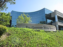
The corporate headquarters of Harbor Freight Tools, The Cheesecake Factory and DTS Inc. are located in Calabasas. Calabasas is also known as one of the wealthiest cities in the United States.[28]
Top employers[]
According to the city's 2018 Comprehensive Annual Financial Report,[29] the top employers in the city are:
| # | Employer | # of employees |
|---|---|---|
| 1 | The Cheesecake Factory | 1,179 |
| 2 | Harbor Freight Tools | 896 |
| 3 | Las Virgenes Unified School District | 683 |
| 4 | Viewpoint School | 305 |
| 5 | Keysight Technologies | 273 |
| 6 | All Motorists Ins Agency | 210 |
| 7 | Alcatel Internetworking, Inc. | 200 |
| 8 | Bob Smith BMW & Mini | 157 |
| 9 | Xperi | 140 |
| 10 | Valley Crest Landscaping Co. | 126 |
Technology center[]
During the dot-com bubble, a number of technology companies were located on a stretch of Agoura Rd parallel to the US 101 Freeway, leading that area of Calabasas to develop a reputation as the "101 Technology Corridor". These businesses included several computer-networking companies Xylan (later Alcatel-Lucent), Netcom Systems (later Spirent Communications), Ixia Communications, j2 Global Communications, Tekelec, and software company Digital Insight.[30] Although some of these companies have since relocated, been acquired, or ceased operations, the area continues to be home to a significant technology presence.
Arts and culture[]
Annual events[]
The city sponsors many annual events including:
- The Pumpkin Festival[31]
- Eggstravaganza[32]
- The Fine Arts Festival[33]
- The Fourth of July Spectacular[34]
- The Calabasas Film Festival[35]
Weekly events[]
There is a farmers market located on Calabasas Road that happens every Saturday from 8:00 in the morning and goes until 1:00 in the afternoon.[36]
Tourism[]
Claretville of Calabasas / King Gillette Ranch[]


The Claretians (The Missionary Sons of the Immaculate Heart of Mary in Rome, or The Claretian Order) of the Roman Catholic Church had come to Southern California by way of Mexico in the early 1900s, working in Los Angeles inner-city missions. From 1952 to 1977, they operated the Theological Seminary of Claretville and the Immaculate Heart Claretian Novitiate on the former Gillette Estate, which they renamed Claretville.[37] Thomas Aquinas College rented the Claretville campus from the Claretians from 1971 to 1978. When the Claretians sold their Claretville property in 1978 to Clare Prophet and her Church Universal and Triumphant, Thomas Aquinas College[38] began construction on a permanent campus in Santa Paula, California.[39] The Gillette Estate/Claretville property is known as the King Gillette Ranch and is part of Malibu Creek State Park.[10] The land and historic structures by architect Wallace Neff are at the intersection of Mulholland Highway and Las Virgenes Road in unincorporated Calabasas.[40][41]
Hindu temple[]
The Malibu Hindu Temple, located on Las Virgenes Road in unincorporated Calabasas, is visited by many Hindus and others from both in and outside California. The Hindu Temple Society of Southern California was incorporated in the State of California as a nonprofit religious organization on August 18, 1977.[42][10]
Parks and recreation[]
Brandon's Village is a public playground located at Gates Canyon Park in Calabasas. It serves over 5,000 special-needs children from Calabasas and surrounding communities. Designed by Shane's Inspiration, a nonprofit organization that designs and builds universally accessible playgrounds, Brandon's Village is about 1 acre (4,000 m2) in size. Its playground equipment is over 70% independently playable by children with disabilities, and also provides meaningful and stimulating play opportunities for children without disabilities.[43]
Grape Arbor Park is a small park and green space situated on Lost Road Hills off Ventura Freeway in Calabasas, and serves the surrounding residential area. The park includes a baseball diamond, tennis court, sand volleyball court, playground, and picnic tables. In 2018, the park was damaged during the Woolsey Fire, with playground equipment, landscaping, and irrigation needing repair. The park was renovated by the city, with reconstruction being completed in 2020.[44][45]
Calabasas Bark Park is a small dog park with a grass space and separated gated children's area with water fountains. The park is also connected to a small maintained hiking trail.[46][47]
Wild Walnut Park is an outdoor preserve located along Mulholland Highway in Calabasas. The park features walking paths and picnic benches. In 2020, a portion of the park was approved to be used as a dog park. [48][49][50]
Government[]
City policies are decided by a five-member city council. Council members serve four-year terms and are elected at-large. Each year, the council chooses one of its members to act as mayor and preside over city council meetings.[2]
In the California State Legislature, Calabasas is in the 27th Senate District, represented by Democrat Henry Stern, and in the 45th Assembly District, represented by Democrat Jesse Gabriel.[51]
In the United States House of Representatives, Calabasas is in California's 33rd congressional district, represented by Democrat Ted Lieu.[52]
Environmental stewardship[]
In 2005, Calabasas voters overwhelmingly passed Measure D. The ordinance protects and preserves existing areas of open space in Calabasas by requiring two-thirds voter approval before any land in the city designated as open space may be redesignated for another use.[53]
In 2007, the Calabasas City Council adopted Ordinance 2007-233, banning retail food establishments, nonprofit food providers, and city facilities from using food-packaging materials made of expanded polystyrene (Styrofoam).[54] The ordinance requires food-service establishments in Calabasas to use environmentally acceptable packaging starting March 31, 2008, and to report ongoing compliance with this ordinance on the first business day of each calendar year.
In 2011, the City Council passed Ordinance 2011-282 which banned grocery stores, convenience stores (minimarts), liquor stores, drug stores, and pharmacies from furnishing single-use plastic carryout bags. The ordinance also requires that if those businesses furnish paper carryout bags, they must charge customers 10 cents per bag.
Second-hand smoke ordinance[]
In February 2006, Calabasas enacted the Comprehensive Second-Hand Smoke Control Ordinance that prohibits smoking in all public places in the City of Calabasas where other persons may be exposed to second-hand smoke.[55] These places include indoor and outdoor businesses, hotels, parks, apartment common areas, restaurants, and bars where people can be reasonably expected to congregate or meet. Under the law, smoking outdoors in public areas within the city is restricted to select "designated smoking areas". The law went into effect on March 16, 2006, garnering much local and national media attention. The full text of the ordinance may be found at Calabasas' official website.[56] The ordinance was expanded in early 2008, requiring 80% of rental apartment buildings to be permanently designated as non-smoking units by January 1, 2012.
Education[]
Calabasas residents are zoned to schools in the Las Virgenes Unified School District. The district also serves the nearby communities of Agoura Hills, Bell Canyon, and Hidden Hills, and certain smaller areas. Calabasas High School is a part of the district.
In January 2004, Alice C. Stelle Middle School, located at the corner of Mulholland Highway and Paul Revere Road, was opened to serve the eastern half of the city. The western half is served by Arthur E. Wright Middle School, located on Las Virgenes Road, which prior to 2004, was the city's only middle school.
Calabasas is also home to Chaparral, Round Meadow, Lupin Hill, and Bay Laurel public elementary schools, which are part of the Las Virgenes Unified School District, as well as the private Viewpoint School.[57]
Infrastructure[]
Public services[]
Calabasas funds its own public transportation in the form of a shuttle and trolley service.[58] It augments the service provided by the Los Angeles County Metropolitan Transportation Authority[59] and funds its own municipal library (as opposed to participating in the Los Angeles County library system), runs the Calabasas Tennis and Swim Center, and has a protected and maintained historical district called "Old Town Calabasas".[60]
Calabasas has United States Postal Service post office locations in Suite 10 at 4774 Park Granada, and at the Malibu Shell Post Office at 4807 Las Virgenes Road.[61][62]
The Los Angeles County Sheriff's Department operates the Malibu/Lost Hills Station at 27050 Agoura Road in Calabasas.[63][64]
The Los Angeles County Fire Department provides medical and fire suppression services to Calabasas.
In popular culture[]
Calabasas Park Golf Club sits where Warner Bros. Ranch was located.[65] Films shot there include Showboat (1951), High Noon (1952), Calamity Jane (1953), Stalag 17 (1953), and Carousel (1956).[66]
Author Lee Goldberg's novel Lost Hills, the first in a series of books about Detective Eve Ronin, the youngest homicide detective in the history of the Los Angeles County Sheriff's Department, is set in Calabasas. The novel debuted in January 2020 and will be followed by a sequel, Bone Canyon, in January 2021 that is also set in Calabasas.[67] In addition, the family of Kate O'Hare, the heroine of the five New York Times bestselling "Fox & O'Hare" that thrillers that Goldberg co-wrote with Janet Evanovich, lives in Calabasas.
The titular character of the TV show Ray Donovan lives in Calabasas with his wife and two children.[68]
Notable people[]
- Charlie Adler, actor, director[69]
- Shohreh Aghdashloo, actress, author[70]
- Michael Ansara, actor[71]
- Shiri Appleby, actor[72]
- Adrienne Bailon, singer, actress, host[73]
- Justin Bieber, singer[74]
- Brandon Boyd, musician, singer[75]
- Marcia Clark, prosecutor, author, television correspondent[76]
- Lee Goldberg, author, screenwriter, publisher, producer[77]
- D. L. Hughley, actor, commentator, radio host, author, comedian[78]
- Kris Jenner, television personality[79]
- Kylie Jenner, television personality[80]
- Ken Jeong, actor and comedian[81]
- Kim Kardashian, television personality[79]
- Khloé Kardashian, television personality[74]
- Keiran Lee, actor, director, producer[82]
- Jake Paul, internet personality and actor[83]
- Ed Shaughnessy, musician[84]
- Daniel Steres, professional soccer player[85]
- Joni Eareckson Tada, author[86][87]
- Jordyn Woods, model and entrepreneur[88]
Sister cities[]
 Anqing, China
 Mevaseret Zion, Israel
See also[]
- Canoga Park, Los Angeles
- Flora of the Santa Monica Mountains
- History of the San Fernando Valley to 1915
- Los Angeles Pet Memorial Park
- Rancho El Escorpión
- West Hills, Los Angeles
References[]
- ^ "California Cities by Incorporation Date". California Association of Local Agency Formation Commissions. Archived from the original (Word) on November 3, 2014. Retrieved August 25, 2014.
- ^ Jump up to: a b "Calabasas City Council". Archived from the original on April 30, 2020. Retrieved April 10, 2020.
- ^ "2019 U.S. Gazetteer Files". United States Census Bureau. Retrieved July 1, 2020.
- ^ "Calabasas". Geographic Names Information System. United States Geological Survey. Retrieved January 19, 2015.
- ^ "Calabasas (city) QuickFacts". United States Census Bureau. Archived from the original on March 29, 2015. Retrieved April 7, 2015.
- ^ Jump up to: a b "Population and Housing Unit Estimates". United States Census Bureau. May 24, 2020. Retrieved May 27, 2020.
- ^ "ZIP Code(tm) Lookup". United States Postal Service. Retrieved November 17, 2014.
- ^ "Number Administration System - NPA and City/Town Search Results". Archived from the original on March 20, 2012. Retrieved January 18, 2007.
- ^ Jump up to: a b "Espiritu and Miguel Leonis Adobe in Calabasas - California". you-are-here.com. Archived from the original on August 9, 2012. Retrieved December 21, 2007.
- ^ Jump up to: a b c d Jaffe, Matt (October 18, 2018). "How to Make a Day of a Trip to Calabasas". Los Angeles Magazine. Retrieved May 12, 2019.
- ^ according to the U.S. Census Bureau website, factfinder.census.gov.
- ^ Hogle, Gene NAC Green Book of Pacific Coast Touring (1931) National Automobile Club p.25
- ^ ""Archived copy". Archived from the original on February 9, 2015. Retrieved 2015-02-19.CS1 maint: archived copy as title (link) "
- ^ ""Archived copy". Archived from the original on February 9, 2015. Retrieved 2015-02-19.CS1 maint: archived copy as title (link)"
- ^ "Calabasas History". City of Calabasas. City of Calabasas. Retrieved August 19, 2020.
- ^ "Cities within the County of Los Angeles" (PDF). Lacounty.gov. Retrieved December 11, 2020.
- ^ Moshtaghian, Artemis; Melas, hloe; Simon, Darran (January 27, 2020). "Kobe Bryant and his daughter, Gianna, among 9 killed in a helicopter crash in California". CNN. Retrieved February 6, 2020.
- ^ "San Fernando Valley, CA". thevalley.net. The Valley Economic Alliance. Retrieved November 29, 2016.
- ^ BIEDERMAN, PATRICIA WARD (October 28, 2001). "Echoes of an Artistic Past Still Resound". Los Angeles Times. Retrieved March 7, 2019.
- ^ "Records and Averages for Calabasas, CA". msn.com. MSN. Retrieved March 8, 2021.
- ^ "Calabasas, California (91302) Climate Normals". WeatherForYou.com. Retrieved March 8, 2021.
- ^ McCarthy, Bonnie (July 12, 2016). "Home of the Day: Fruit trees and famous neighbors in Calabasas". Los Angeles Times. Retrieved July 12, 2016.
- ^ Risling, Greg (May 5, 2000). "Remains Said to Be Native American's". Los Angeles Times. Retrieved July 12, 2016.
- ^ "Census of Population and Housing". Census.gov. Retrieved June 4, 2015.
- ^ "2010 Census Interactive Population Search: CA - Calabasas city". U.S. Census Bureau. Archived from the original on July 15, 2014. Retrieved July 12, 2014.
- ^ "Calabasas (city) QuickFacts from the US Census Bureau". Archived from the original on March 29, 2015. Retrieved May 28, 2015.
- ^ "Calabasas city, California - Fact Sheet - American FactFinder". Factfinder.census.gov. Archived from the original on August 9, 2012. Retrieved May 6, 2009.
- ^ Winslow, Hailey (February 28, 2020). "Calabasas beats out Beverly Hills as one of richest cities in U.S." FOX 11. Retrieved June 2, 2020.
- ^ "City of Calabasas CAFR" (PDF). Archived from the original (PDF) on October 13, 2019. Retrieved October 13, 2019.
- ^ "Our Properties - Corporate Center at Malibu Canyon". The Johnston Group. Archived from the original on April 17, 2009. Retrieved May 6, 2009.
- ^ "Calabasas Pumpkin Festival". Calabasas Pumpkin Festival. Retrieved November 9, 2010.
- ^ "Eggstravaganza Egg Hunt". Cityofcalabasas.com. April 3, 2010. Archived from the original on December 3, 2010. Retrieved November 9, 2010.
- ^ "Calabasas Arts Council". Calabasas Arts Council. Retrieved November 9, 2010.[permanent dead link]
- ^ "July 4th Fireworks Spectacular". Cityofcalabasas.com. July 4, 2010. Retrieved November 9, 2010.[permanent dead link]
- ^ "Calabasas Film Festival". Cityofcalabasas.com. September 9, 2014. Archived from the original on November 7, 2016. Retrieved November 7, 2016.
- ^ "Calabasas Farmer's Market".
- ^ "Archived copy" (PDF). Archived from the original (PDF) on March 11, 2010. Retrieved March 9, 2010.CS1 maint: archived copy as title (link)
- ^ "Home - Thomas Aquinas College". Retrieved May 28, 2015.
- ^ [1] museum of san fernando valley_Claretville
- ^ "Santa Monica Mountains Conservancy". Smmc.ca.gov. December 1, 2002. Archived from the original on November 8, 2010. Retrieved November 9, 2010.
- ^ "Parks". LAMountains.com. Archived from the original on October 25, 2010. Retrieved November 9, 2010.
- ^ "The Hindu temple Society of Southern California". Archived from the original on April 6, 2014. Retrieved May 12, 2019.
- ^ "Brandon's Village opened in 2006". Archived from the original on May 20, 2007.
- ^ "Grape Arbor makes comeback following fire". The Acorn. Retrieved June 7, 2020.
- ^ "Grape Arbor Park". Lacounty.com. Retrieved June 7, 2020.
- ^ "Calabasas Bark Park". Bring Fido. Retrieved June 7, 2020.
- ^ "Bark Park Trail in Calabasas". Conejo Valley Guide. Retrieved June 7, 2020.
- ^ Wittner, Michael. "Temporary Dog Park Opens In Calabasas". patch.com. Patch. Retrieved December 11, 2020.
- ^ "Wild Walnut Park". Lacounty.gov. Retrieved June 7, 2020.
- ^ "The View From Calabasas: Wild Walnut Park". Patch. Retrieved June 7, 2020.
- ^ "Statewide Database". UC Regents. Archived from the original on February 1, 2015. Retrieved October 20, 2014.
- ^ "California's 33rd Congressional District - Representatives & District Map". Civic Impulse, LLC.
- ^ [2] Archived March 26, 2009, at the Wayback Machine
- ^ [3] Archived January 14, 2011, at the Wayback Machine
- ^ "Secondhand Smoking Ordinance". Archived from the original on June 1, 2015. Retrieved May 28, 2015.
- ^ "An Ordinance Of The City Of Calabasas regulating second-hand smoke and amending the Calabasas municipal code" (PDF). Archived from the original (PDF) on February 19, 2006. Retrieved March 20, 2006.
- ^ "Viewpoint School". Viewpoint.org. Retrieved May 6, 2009.
- ^ "Transportation/Transit Division". Cityofcalabasas.com. August 27, 2008. Retrieved May 6, 2009.[permanent dead link]
- ^ "metro.net | Transit Services and Information for Los Angeles County: line 161" (PDF). Mta.net. Archived from the original (PDF) on September 28, 2007. Retrieved May 6, 2009.
- ^ [4] Archived March 1, 2010, at the Wayback Machine
- ^ "Post Office Location - CALABASAS." United States Postal Service. Retrieved on December 6, 2008.
- ^ "Post Office Location - MALIBU SHELL." United States Postal Service. Retrieved on December 6, 2008.
- ^ "Malibu/Lost Hills Station Archived September 7, 2015, at the Wayback Machine." Los Angeles County Sheriff's Department. Retrieved on January 21, 2010.
- ^ "Calabasas city, California Archived June 6, 2011, at the Wayback Machine." U.S. Census Bureau. Retrieved on January 21, 2010.
- ^ "History". Calabasas Country Club.
- ^ Alleman, Richard (2013). Hollywood: The Movie Lover's Guide: The Ultimate Insider Tour of Movie L.A. Crown/Archetype. Page 432. ISBN 9780804137775.
- ^ "Lost Hills Finds Home at Thomas & Mercer". Publishers Weekly.
- ^ Erickson, Steve (July 7, 2014). ""Ray Donovan": A Messy Business". Los Angeles Magazine. Retrieved December 23, 2020.
- ^ Biederman, Patricia (August 6, 1999). "Calabasas Actor Speaks for Many in the 'Toon World". Los Angeles Times.
- ^ Lacher, Irene (June 1, 2013). "Shohreh Aghdashloo, from Tehran to Hollywood". Los Angeles Times. Retrieved August 30, 2020.
- ^ Goodman, Jessica (August 2, 2013). "Michael Ansara Dead: 'Star Trek' Actor Dies At 91". Huffington Post.
- ^ "Actress Shiri Appleby chats about Jewish influences and life on the small screen - Hollywood". The Jewish Journal of Greater Los Angeles. August 12, 2015.
- ^ Flemming, Jack. "tv host adrienne bailon buys calabasas charmer for 3 million". La Times. Retrieved May 27, 2020.
- ^ Jump up to: a b Griffith, Carson. "A Look Back at Justin Bieber's House Rental History". Architectural Digest. Retrieved April 29, 2020.
- ^ "Curriculum Vitae of Brandon Boyd" (PDF). Brandon Boyd official website. Archived from the original (PDF) on September 12, 2018. Retrieved September 12, 2018.
- ^ Galloway, Stephen (March 30, 2016). "Marcia Clark on Her Rape, Scientology Flirtation and When She Last Saw O.J." The Hollywood Reporter.
- ^ "Official Facebook page of Lee Goldberg". Facebook query. Retrieved November 6, 2018.
- ^ Sanders, Sam (July 31, 2018). "D.L. Hughley On 'How Not To Get Shot'". National Public Radio.
- ^ Jump up to: a b "Kim Kardashian West, Kris Jenner quietly close on new condos in Calabasas". Los Angeles Times. October 24, 2017.
- ^ Weaver, Hilary (May 30, 2020). "See Photos of Kylie Jenner's $3.6 Million Calabasas Starter Home That's on the Market Again". ELLE.
- ^ "Comedian Ken Jeong buys an upgraded home in Calabasas for $3.95 million". Los Angeles Times. October 19, 2016. Archived from the original on August 5, 2020. Retrieved April 29, 2020.
- ^ Gallone, Jill (May 6, 2016). "Keiran Lee: he's Britain's top porn star but gets his kicks out of Derby County". Derbytelegraph. Derby Telegraph. Retrieved April 6, 2017.
- ^ Andrews, Travis M. (July 15, 2020). "YouTuber Jake Paul blasted by Calabasas mayor for throwing massive party 'acting like covid does not exist'". The Washington Post. Archived from the original on July 16, 2020. Retrieved August 5, 2020.
- ^ Wilson, Scott (August 19, 2016). Resting Places: The Burial Sites of More Than 14,000 Famous Persons, 3d ed. McFarland. ISBN 9781476625997 – via Google Books.
- ^ "Daniel Steres". LA Galaxy.
- ^ "Joni Eareckson Tada". Christianity Today. Retrieved December 6, 2018.
- ^ Pascal, Susan (May 31, 2013). "Joni Eareckson Tada Profiled on 'Good Morning, America'". Patch Media.
Joni, who runs The Joni and Friends International Disability Center located in Agoura Hills, and Ken live in Calabasas.
- ^ Gibson, Francesca (September 23, 2020). "10 things you probably didn't know about Jordyn Woods". Cosmopolitan. Retrieved April 29, 2021.
External links[]
| Wikimedia Commons has media related to Calabasas, California. |
| Wikivoyage has a travel guide for Calabasas. |
| show Municipalities and communities of Los Angeles County, California, United States |
|---|

| show Greater Los Angeles Area |
|---|

| show Authority control |
|---|
- Calabasas, California
- 1991 establishments in California
- Cities in Los Angeles County, California
- Communities in the San Fernando Valley
- Incorporated cities and towns in California
- Populated places established in 1991
- Populated places in the Santa Monica Mountains
- San Fernando Valley
- Simi Hills