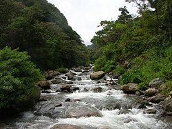
Caldera River
| Caldera River | |
|---|---|
 | |
 | |
| Native name | Río Caldera |
| Location | |
| Country | Panama |
| Physical characteristics | |
| Source | Volcán Barú |
| • location | Chiriqui Province, Panama |
| • coordinates | 8°50′55″N 82°29′15″W / 8.848534°N 82.487498°W |
| Mouth | |
• coordinates | 8°37′10″N 82°21′23″W / 8.61944°N 82.35639°WCoordinates: 8°37′10″N 82°21′23″W / 8.61944°N 82.35639°W |

The Caldera River (Spanish: Rio Caldera) is a river of Panama. It passes through the town of Boquete and flows through the Volcán Barú National Park in Chiriqui. It flooded its banks in November 2008. It caused extensive damage to infrastructure and many roads had to be repaired.
External links[]
| Authority control |
|
|---|
Categories:
- Rivers of Panama
- North America river stubs
- Panama geography stubs