Calslagen
Calslagen | |
|---|---|
Buurtschap (hamlet) | |
 | |
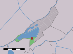 The hamlet (dark red) and the statistical district (light green) of Calslagen in the municipality of Aalsmeer. | |
| Coordinates: 52°14′00″N 4°43′51″E / 52.23333°N 4.73083°ECoordinates: 52°14′00″N 4°43′51″E / 52.23333°N 4.73083°E | |
| Country | Netherlands |
| Province | North Holland |
| Municipality | Aalsmeer |

Calslagen (52°14′N 4°44′E / 52.233°N 4.733°E) is a hamlet in the Dutch province of North Holland. It is a part of the municipality of Aalsmeer, and lies about 9 km south of Hoofddorp.
Until 1854, Calslagen (then spelled "Kalslagen") was a separate municipality, under the name of Kalslagen en Bilderdam.[1]
The statistical area "Calslagen", which covers the hamlet and a large part of the lake area Westeinderplassen, has a population of around 550.[2]
References[]
- ^ Ad van der Meer and Onno Boonstra, Repertorium van Nederlandse gemeenten, KNAW, 2011.
- ^ Statistics Netherlands (CBS), Statline: Kerncijfers wijken en buurten 2003-2005 Archived 2006-07-24 at WebCite. As of 1 January 2005.
This North Holland location article is a stub. You can help Wikipedia by . |
Categories:
- Populated places in North Holland
- Aalsmeer
- North Holland geography stubs