Calumet, Lexington
Calumet | |
|---|---|
Neighborhood of Lexington, Kentucky | |
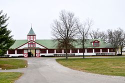 Stables at Calumet Farm | |
| Country | United States |
| State | Kentucky |
| County | Fayette |
| City | Lexington |
| Area | |
| • Total | 0.266 sq mi (0.69 km2) |
| Population (2000) | |
| • Total | 750 |
| • Density | 2,882/sq mi (1,087/km2) |
| Time zone | UTC-5 (Eastern (EST)) |
| • Summer (DST) | UTC-4 (EDT) |
| ZIP code | 40504 |
| Area code(s) | 859 |
Calumet is a neighborhood in northern Lexington, Kentucky, United States. Its boundaries are Viley Road to the west, Versailles Road to the south, New Circle Road to the north, and Wolf Run Creek to the east.[1]
Neighborhood statistics[]
- Area: 0.266 square miles (0.69 km2)
- Population: 750
- Population density: 2,822 people per square mile (1,087/km2)
- Median household income: $49,446[1]
References[]
- ^ a b Calumet Neighborhood Profile city-data.com. Retrieved on 2011-01-02


Coordinates: 38°03′07″N 84°33′22″W / 38.052°N 84.556°W

This Fayette County, Kentucky state location article is a stub. You can help Wikipedia by . |
Categories:
- Neighborhoods in Lexington, Kentucky
- Fayette County, Kentucky geography stubs