Cambodia–Thailand border
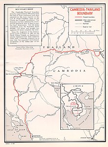
The Cambodia–Thailand border is the international border between Cambodia and Thailand. The border is 817 km (508 mi) in length and runs from the tripoint with Laos in the north-east to the Gulf of Thailand in the south.[1]
Description[]
The border starts in the north-east at the tripoint with Thailand at Preah Chambot peak in the Dângrêk Mountains and the follows the crest of the mountains westwards.[2] Upon leaving the mountains the border turns south-westwards in a broad arc, occasionally utilising rivers such as the Svay Chek, the Sisophon, the Phrom Hot and Mongkol Borei. It then proceeds south, partly along the Cardamom Mountains, terminating at the Gulf of Thailand coast. This latter section runs very close to the Gulf, producing a long, thin strip of Thai territory.[2]
History[]
The boundary area has historically switched back and forth between various Khmer and Thai empires.[2] From the 1860s France began establishing a presence in the region, initially in modern Cambodia and Vietnam, and later Laos, with the colony of French Indochina being created in 1887.[2][3] In 1867 a Franco-Thai treaty confirmed Thai ownership of the Battambang and Angkor (Nakhou Siemrap) regions.[2][3] In 1896 Britain (based in Burma) and France agreed to leave Siam (the then name for Thailand) as a buffer state between their respective colonies.[2] However France continued to expand at the expense of Siam, annexing northern Cambodia in 1904 and then Battambang, Sisophon and Siam Nakhon/Siem Reap in 1907, whilst ceding Trat to Siam. The modern Cambodian-Thai border was as such delimited through several treaties between France and Siam between 1867 and 1907.[2][3] Following Japan's invasion of French Indochina in 1940 the areas ceded to France in 1904 and 1907 were returned to Thailand, however this was reversed following Japan's defeat and the pre-war border restored in 1946.[2][3]
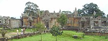
Cambodia gained independence in 1953, and the two state since then have had a fractious relationship.[4] A dispute arose in the late 1950s over the ownership of the Preah Vihear Temple, which lies adjacent to the border in the Dângrêk Mountains.[2] In 1962 the case was referred to the International Court of Justice, which ruled in favour of Cambodia, however Thailand expressed reservations as to the outcome.[2][5] The mid-1960s also saw a dispute over ownership of Ko Kut island.[3] These disputes faded as Cambodia became engulfed in a series of conflicts in the following decades and the disastrous rule of the Khmer Rouge, with thousands of refugees crossing the border.[3] By 1981, over 250,000 Cambodian and Vietnamese refugees lived in twenty camps along the border, supported by international aid agencies and the United Nations Border Relief Operation.[6] Sporadic fighting broke out along the border following Vietnam's invasion of Cambodia in 1979, continuing throughout the 1980s until Vietnam withdrew from the country in 1989.[7] In an effort to stop Khmer Rouge infiltration from Thailand, Cambodia built a large fortified fence along the border in the second half of the 1980s.[8][9] Since the advent of peace in Cambodia in the early 1990s relations with Thailand have once again soured over the Preah Vihear issue, as well as, to a lesser extent, Ko Kut island.[3] A border commission was set up in 1995 in an attempt to settle the issues peacefully, however it has made little progress and a full border demarcation satisfactory to both sides remain outstanding.[3][10][11]
Border crossings[]

There are several official border crossings:[12]
- Aranyaprathet, Thailand – Poipet, Cambodia
- Hat Lek, Thailand – Koh Kong, Cambodia (Cham Yeam Checkpoint)
- Chong Jom, Thailand – O Smach, Cambodia
- Chong Sa Ngam, Thailand – Anlong Veng, Cambodia
- Ban Pakard, Chantaburi, Thailand – Phsar Prom Pailin, Cambodia (Prom Checkpoint)
- Ban Laem, Chantaburi, Thailand – Daung Lem, Cambodia (Daung Checkpoint)
See also[]
- Cambodia–Thailand relations
- Cambodian–Thai border dispute
- Cambodian humanitarian crisis
- Vietnamese border raids in Thailand
- Indochina refugee crisis
- Nong Chan Refugee Camp
- Nong Samet Refugee Camp
- Sa Kaeo Refugee Camp
- Site Two Refugee Camp
- Khao-I-Dang
References[]
- ^ "Cambodia". CIA World Factbook. Retrieved 19 September 2020.
- ^ a b c d e f g h i j "International Boundary Study No. 40 – Cambodia - Thailand Boundary (Revised)" (PDF). US Department of State. 23 November 1966. Retrieved 20 September 2020.
- ^ a b c d e f g h St John, Ronald Bruce. "The Land Boundaries of Indochina: Cambodia, Laos and Vietnam" (PDF). International Boundaries Research Unit, Department of Geography, University of Durham. Archived from the original (PDF) on 13 November 2020. Retrieved 17 September 2020.
- ^ Kamm, Henry (1998). Cambodia: report from a stricken land. New York: Arcade Publishing. p. 27. ISBN 1-55970-433-0.
- ^ Case Concerning the Temple of Preah Vihear (Cambodia v. Thailand), Merits Archived June 3, 2013, at the Wayback Machine, [1962] I.C.J. Reports 6, p. 23
- ^ Shawcross W. The Quality of Mercy: Cambodia, Holocaust, and Modern Conscience. New York: Simon and Schuster, 1984
- ^ Puangthong Rungswasdisab, Thailand's Response to the Cambodian Genocide
- ^ Margaret Slocomb, "The K5 Gamble: National Defence and Nation Building under the People's Republic of Kampuchea", Journal of Southeast Asian Studies (2001), 32 : 195-210 Cambridge University Press
- ^ NewScientist - "The killing minefields of Cambodia"
- ^ "Preah Vihear temple: Disputed land Cambodian, court rules". BBC News. November 11, 2013. Retrieved 11 November 2013.
- ^ Walsh, Eddie (May 24, 2011). "China and Thai-Cambodia Spat". The Diplomat. Archived from the original on July 29, 2011. Retrieved July 25, 2011.
- ^ "Overland Border Crossings". Canby Publications. Retrieved 20 September 2020.
| Wikimedia Commons has media related to Cambodia-Thailand border. |
- Cambodia–Thailand border
- Cambodia–Thailand relations
- Borders of Cambodia
- Borders of Thailand
- International borders