Canim Falls
Canim Falls and lava flows.
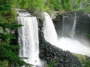
Canim Falls is a 23 metre high waterfall on the Canim River between Canim Lake and Mahood Lake in in the Cariboo region of the Central Interior of British Columbia, Canada.[1][2] The waterfall has eroded steadily upstream and created a 4 km (2.5 mi) long canyon cut into a lava plateau associated with the Wells Gray-Clearwater volcanic field.
A trail from Mahood Lake Road leads to Canim Falls and nearby Mahood Falls.
"Canim" means a type of large canoe in the Chinook Jargon. Coordinates: 51°52′00″N 120°35′35″W / 51.86667°N 120.59306°W
See also[]
References[]
- ^ "Canim Falls". BC Geographical Names.
- ^ Neave, Roland (2015). Exploring Wells Gray Park, 6th edition. Wells Gray Tours, Kamloops, BC. ISBN 978-0-9681932-2-8.
This article about a location in the Cariboo Regional District, Canada is a stub. You can help Wikipedia by . |
Categories:
- Waterfalls of British Columbia
- Landforms of the Cariboo
- Chinook Jargon place names
- Wells Gray-Clearwater
- Cariboo Regional District geography stubs