Canta
Canta | |
|---|---|
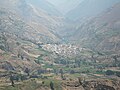
 View of the town of Canta | |
 Canta Location in Peru | |
| Coordinates: 11°28′1.2″S 76°37′26.4″W / 11.467000°S 76.624000°WCoordinates: 11°28′1.2″S 76°37′26.4″W / 11.467000°S 76.624000°W | |
| Country | |
| Region | Lima |
| Province | Canta |
| District | Canta |
| Government | |
| • Mayor | Arturo Paredes Salcedo (2019-2022) |
| Elevation | 2,819 m (9,249 ft) |
| Population (2017) | |
| • Total | 2,385 |
| Demonym(s) | Canteño/a |
| Time zone | UTC−5 (PET) |

Canta is a town in the Lima Region, in western Peru. The town is located on the Chillón River and is the capital of the Canta Province. With a population of 2,385 (2017 census), it is also the capital of Canta District. It is frequently visited by tourists from Lima because of its quietness and the beauty of its natural landscapes. The town's altitude is 2,819 m above sea level.
Etymology[]
The word canta comes from the Cauqui language spoken by the ancient inhabitants and their meaning can be indicated with these two meanings:
- canta = tie to catch vicunas
- canta = hillside, decline[1]
Location[]
The town is 103 kilometres (64 mi) from Lima, about a three-hour bus ride, and is often visited by geography students from the Pontificia Universidad Catolica del Peru. The small town of Obrajillo is nearby.
Aerial photo of Canta, Peru
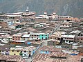
Aerial photo of Canta, Peru


History[]
At some time in the 16th century, it was dominated by the Inca Pachacutec during his path to the north. The Spanish conquistadors found Canta in a prosperous locality. It was given like a parcel to don Nicolás de Ribera. During the campaign for the Independence for the Spanish crown, its people had given strong support to the cause of liberation. For that, in 1839 it was declared "heroic village".
References[]
- ^ Homero Huamán (1998). Canta. Potencial turístico.
External links[]
- (in Spanish) La Viuda myth
- (in Spanish) Cantamarca, archaeological site
| hide Authority control | |
|---|---|
| General | |
| National libraries | |
- Populated places in the Lima Region