Cape Alexander, Greenland
| Cape Alexander | |
|---|---|
| Ullersuaq, Uvdlerssuak, Sarfalik | |
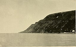 View of Cape Alexander | |
 | |
| Location | Avannaata, Greenland |
| Coordinates | 78°11′N 73°3′W / 78.183°N 73.050°WCoordinates: 78°11′N 73°3′W / 78.183°N 73.050°W |
| Offshore water bodies | Baffin Bay |
| Area | Arctic |

Cape Alexander (Greenlandic: Ullersuaq, also Uvdlerssuak and Sarfalik; Danish: Kap Alexander) is a headland in the Baffin Bay, northwest Greenland, Avannaata municipality. It is one of the important landmarks of Greenland.
Geography[]
Cape Alexander is located in , at the western end of Hartstene Bay with the to the east and Sutherland Island to the southeast.[1] It is the westernmost point of the island of Greenland.[2]
The small Carey Islands are located further to the west; among them Nordvestø (73°10'W), the westernmost point of Greenland as a territory.[3]
 Ullersuaq amongst the extreme points of Greenland |
See also[]
References[]
- ^ "Kap Alexander". Mapcarta. Retrieved 10 April 2016.
- ^ Cape Alexander, Greenland at GEOnet Names Server
- ^ 1:1,000,000 scale Operational Navigation Chart, Sheet B-8, 3rd edition
This Greenland location article is a stub. You can help Wikipedia by . |
Categories:
- Headlands of Greenland
- Greenland geography stubs