Cape Aya
| Cape Aya | |
|---|---|
| Мис Айя | |
 Cape Aya | |
 Location in Sevastopol | |
| Location | Sevastopol, Crimea |
| Coordinates | 44°25′44″N 33°38′56″E / 44.42889°N 33.64889°ECoordinates: 44°25′44″N 33°38′56″E / 44.42889°N 33.64889°E |

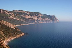
Cape Aya ("the holy one" in Greek, Άγια) is a rocky promontory jutting out into the Black Sea southeast of Balaklava. This 13-km-long offspur of the Crimean Mountains separates (to the east) from Balaklava Bay (to the west).
The highest point, (literally "Blue Cliff") is 559 m (1,834 ft). The headland is full of grottoes; it is protected as a national zakaznik.[1]
A storm off Cape Aya is the subject of one of Aivazovsky's paintings. A Soviet guided missile system was located on Cape Aya.
Viktor Yanukovych, the former President of Ukraine, ordered the construction of a luxurious private residence on Cape Aya. The "New Mezhyhyria" was still unfinished when the 2014 Ukrainian Revolution ousted Yanukovych from his post.[2]
References[]
- ^ Marine Protected Areas for Whales, Dolphins and Porpoises Erich Hoyt - 2012 "The area between Cape Aya and Cape Fiolent, included in this MPA proposal, has also been identified as important habitat for all three cetaceans.
- ^ "В Крыму открыли доступ к мысу Айя, где строили Межигорье-2 - «УДАР»".
| Authority control: National libraries |
|---|
This article about a location in Crimea is a stub. You can help Wikipedia by . |
This Black Sea-related article is a stub. You can help Wikipedia by . |
- Landforms of Sevastopol
- Crimea geography stubs
- Black Sea stubs