Cape Circoncision
Coordinates: 54°24′39″S 3°20′48″E / 54.4109°S 3.3467°E

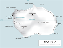
Map of Bouvetøya
Cape Circoncision (Norwegian: Kapp Circoncision) is a peninsula on the north-western edge of subantarctic Bouvet Island. The small peninsula was sighted by the French naval exploration that was led by Jean-Baptiste Charles Bouvet de Lozier on 1 January 1739, the Feast of the Circumcision day -- thus the name. The cape provided the location for the base-camp of the 1928-29 Norwegian expedition.[1]
References[]
- ^ Susan Barr. "Bouvetøya". Store norske leksikon. Retrieved October 1, 2016.
External links[]
- CIA Factbook entry for Bouvet Island Includes a map showing the cape.
| Authority control: National libraries |
|---|
This Bouvet Island location article is a stub. You can help Wikipedia by . |
Categories:
- Headlands of Bouvet Island
- Subantarctic peninsulas
- Norway geography stubs
- Subantarctic island geography stubs