Cape Farewell Archipelago
Native name: Nunap Isua | |
|---|---|
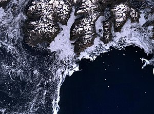
 View of the archipelago with its glaciers from a height of about 11,500 m | |
 | |
| Geography | |
| Location | North Atlantic Ocean Southern Greenland |
| Coordinates | 59°49′N 43°35′W / 59.817°N 43.583°WCoordinates: 59°49′N 43°35′W / 59.817°N 43.583°W |
| Major islands | Sammisoq, Egger, Ikeq, Avallersuaq |
| Highest elevation | 1,546 m (5072 ft) |
| Highest point | Christian IV Island HP |
| Administration | |
Greenland | |
| Municipality | Kujalleq |
| Demographics | |
| Population | 0 |

Cape Farewell Archipelago (also Nunap Isua Archipelago) is an island group located at the southern end of Greenland in Kujalleq municipality. The archipelago takes its name from Cape Farewell, a headland of Egger Island (also known as Itilleq).
Geography[]
The Cape Farewell Archipelago is separated from the mainland's south coast by Prince Christian Sound in the north and by the Torsukattak Fjord in the west.[1] The main islands of the group are characterized as large and mountainous, surrounded by fjord-like passages. There are also several islets and rocks.
Islands[]
Sammisoq (Christian IV Island) is the largest island of the archipelago.[2] Other significant islands include Egger Island (Itilleq), the southernmost of the group, (Nunarssuak), , , Qunnerit, Ikeq, and (Kasit),[3] as well as the Avallersuaq and islets.[4]
 |
See also[]
Bibliography[]
- Prostar (1 January 2005). Prostar Sailing Directions 2005 Greenland and Iceland Enroute. ProStar Publications. ISBN 978-1-57785-753-2.
- United States. Hydrographic Office (1947). Publications.
References[]
- ^ United States. Hydrographic Office 1947, p. 67.
- ^ United States. Hydrographic Office 1947, pp. 73–74.
- ^ Prostar 2005, p. 5.
- ^ Avallersuaq
This Greenland location article is a stub. You can help Wikipedia by . |
- Archipelagoes of Greenland
- Uninhabited islands of Greenland
- Kujalleq
- Greenland geography stubs