Cape Kidnappers


Cape Kidnappers, also known as Te Kauwae-a-Māui and officially known as Cape Kidnappers / Te Kauwae-a-Māui, is a headland at the southeastern extremity of Hawke's Bay on the east coast of New Zealand's North Island and sits at the end of an 8 kilometres (5.0 mi) peninsula which protrudes into the Pacific Ocean. It is 20 kilometres (12 mi) south-east of the city of Napier. Access to the Cape by road stops at Clifton, which is the departure point for many tourists. The Cape Kidnappers Golf Course lies between the headland and the nearby coastal community of Te Awanga.
History[]
The headland was named after an attempt by local Māori to, according to Captain Cook, abduct a member of Cook's crew aboard HMS Endeavour, during a landfall there on 15 October 1769. The crew member was , the 12 year old nephew or servant of Tupaia, the Tahitian arioi who served as the Endeavour's interpreter and guide. Cook's journal states that Taiata was over the side of the ship when a Maori fishing vessel approached the Endeavour offering to trade fish, before seizing the boy and attempting to flee with him. Sailors from Endeavour′s deck immediately opened fire on the fishing boat, killing two Māori and wounding a third.[1]
Ngāti Te Whatuiāpiti's perspective is that Rangatira Te Rangikoianake and his son Hawea led a rescue party in order to free what they thought was a young Māori boy being held captive on the ship. This history was acknowledged in the 2015 Heretaunga Tamatea Deed of Settlement with the Crown.[2]
Taiata promptly jumped overboard and swam back to Endeavour, while the remaining Māori paddled their craft back to shore. A 4-pounder cannon was fired after them from Endeavour′s quarterdeck, but the Māori boat was soon out of range.[1]
“…one of the fishing boat came along side and offer’d us some more fish, the Indian Boy Tiata, Tupia’s servant being over the side, they seized hold of him, pulld him into the boat and endeavourd to carry him off, this obliged us to fire upon them which gave the Boy an oppertunity to jump over board and we brought the Ship too, lower’d a boat into the Water and took him up unhurt. Two or three paid for this daring attempt with the loss of their lives and many more would have suffered had it not been for fear of killing the boy. This affair occation’d my giveing this point of land the name of Cape Kidnappers…’
Cook described the cape as having steep white cliffs on either side, with two large rocks resembling hay stacks near the headland.[1]
Following the passage of the Heretaunga Tamatea Claims Settlement Act 2018, the name of the headland was officially altered to Cape Kidnappers / Te Kauwae-a-Māui.[3] The Māori portion of the name refers to 'the fish hook of Māui'.
Important Bird Area[]
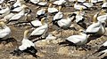
The cape has been identified as an Important Bird Area by BirdLife International because it is a breeding site for over 3000 pairs of Australasian gannets.[4]

Cliffs showing 2019 landslide

Over 5000 gannets nest here
Gannets with chicks
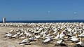
Cape Kidnappers gannet sanctuary, New Zealand
Gannet sanctuary Hawke's Bay


See also[]
- Joseph Bryan Nelson and Kazimierz Wodzicki, who conducted important bird studies there.
References[]
- ^ a b c Beaglehole, John (1968). Beaglehole. pp. 177–178.
- ^ Pollock, Kerryn (1 July 2015). "Naming Cape Kidnappers / Te Kauwae-a-Māui". Te Ara - the Encyclopedia of New Zealand. Archived from the original on 2019-06-07. Retrieved 2 January 2022.
- ^ "NZGB notices – August 2018". Land Information New Zealand. 28 August 2018. Retrieved 5 October 2018.
- ^ BirdLife International. "Important Bird Areas factsheet: Cape Kidnappers". BirdLife. Archived from the original on 2007-07-10. Retrieved 2012-12-11.
Bibliography[]
- Beaglehole, J.C., ed. (1968). The Journals of Captain James Cook on His Voyages of Discovery, vol. I:The Voyage of the Endeavour 1768–1771. Cambridge University Press. OCLC 223185477.
External links[]
| Wikimedia Commons has media related to Cape Kidnappers. |
Coordinates: 39°38′40.89427″S 177°05′35.73″E / 39.6446928528°S 177.0932583°E

- Landforms of the Hawke's Bay Region
- Headlands of New Zealand
- History of the Hawke's Bay Region
- Important Bird Areas of New Zealand
- Hastings District
- Rock formations of New Zealand