Cape Valavielle
| Cape Valavielle | |
|---|---|
 | |
| Coordinates | 60°41′S 44°32′W / 60.683°S 44.533°WCoordinates: 60°41′S 44°32′W / 60.683°S 44.533°W |

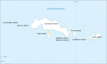
Cape Valavielle is a cape marking the north end of Watson Peninsula on the north coast of Laurie Island, in the South Orkney Islands.
Charted and named by the French expedition, 1837–40, under Captain Jules Dumont d'Urville.
![]() This article incorporates public domain material from the United States Geological Survey document: "Cape Valavielle". (content from the Geographic Names Information System)
This article incorporates public domain material from the United States Geological Survey document: "Cape Valavielle". (content from the Geographic Names Information System) ![]()
This South Orkney Islands location article is a stub. You can help Wikipedia by . |
Categories:
- Laurie Island
- Headlands of the South Orkney Islands
- South Orkney Islands geography stubs