Carbrooke
| Carbrooke | |
|---|---|
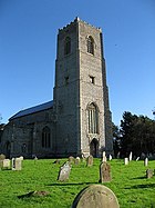 St Peter & St Paul, Carbrooke | |
 Carbrooke Location within Norfolk | |
| Area | 12.66 km2 (4.89 sq mi) |
| Population | 1,176 (2001 census[1]) 2,073 (2011)[2] |
| • Density | 93/km2 (240/sq mi) |
| OS grid reference | TF9494002230 |
| District |
|
| Shire county | |
| Region | |
| Country | England |
| Sovereign state | United Kingdom |
| Post town | Thetford |
| Postcode district | IP25 |
| Dialling code | 01953 |
| Police | Norfolk |
| Fire | Norfolk |
| Ambulance | East of England |
| UK Parliament | |

Carbrooke is a village and civil parish in the Breckland district of mid-Norfolk, East Anglia, England in the United Kingdom. It is 3 miles (4.8 km) from the centre of Watton, 8 miles (13 km) from Dereham and 17 miles (27 km) from its postal town of Thetford. It has an area of 12.66 km2 (4.89 sq mi) with an estimated population of 1,310 in 2007.[3] The measured population at the Census 2011 was 2,076.
The villages name means 'Brushwood brook'. Alternatively, the specific might be a pre-English name for the brook.
The village has a Millennium Green of over 10 acres that is run by Trustees and funded mainly by donations and events, such as the annual Carbrooke Village Fete. The Millennium Green has 2 large grass areas, a fenced children's play area with log play equipment as well as traditional swings etc., an Orchard, Woodland, Nature Pond and Wildflower Meadow areas. It is a location for residents to wander around and for dog walkers from several of the surrounding villages and the town of Watton.
Carbrooke also has a village hall that hosts several services. The local church is St Peter & St Paul[4] in the Benefice of Watton.[5] The Church was originally a Knights Hospitalers of St.John location serving the hospital needs of the Knights Templer and from where St.John Ambulance gets its name. The local school is St Peter & St Paul VC Primary School.
Notable people[]
- George B. Chambers (1881-1969), Vicar of Carbrooke and author
- Edward Dewing (1823–1899), cricketer
References[]
- ^ Census population and household counts for unparished urban areas and all parishes. Office for National Statistics & Norfolk County Council (2001). Retrieved 20 June 2009.
- ^ "Civil Parish population 2011". Neighbourhood Statistics. Office for National Statistics. Retrieved 1 August 2016.
- ^ Breckland Yearbook Archived 2008-11-21 at the Wayback Machine
- ^ St Peter & St Paul Church, Carbrooke
- ^ "Benefice of Watton". Archived from the original on 18 July 2011. Retrieved 6 November 2008.
http://kepn.nottingham.ac.uk/map/place/Norfolk/Carbrooke
External links[]
![]() Media related to Carbrooke at Wikimedia Commons
Media related to Carbrooke at Wikimedia Commons
This Norfolk location article is a stub. You can help Wikipedia by . |
- Villages in Norfolk
- Breckland District
- Civil parishes in Norfolk
- Norfolk geography stubs