Cassini map
This article relies largely or entirely on a single source. (April 2020) |
This article may be expanded with text translated from the corresponding article in French. (March 2015) Click [show] for important translation instructions.
|
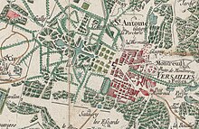
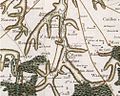
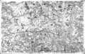
The map of Cassini or map of the Academy is the first topographic and geometric map established of the Kingdom of France as a whole. It was compiled by the Cassini family, mainly César-François Cassini (Cassini III) and his son Jean-Dominique Cassini (Cassini IV) in the 18th century.
It was on a scale of one line to 100 toises, i.e. 1/86,400.
The map was for the time a real innovation and a decisive technical advance. It is the first map to be based on a geodesic triangulation. Four generations of the Cassini carried out the work. The map does not precisely locate dwellings or the boundaries of swamps and forests, but the level of precision of the road network represented is such that by superimposing satellite photos onto map sheets of France, spectacular results are obtained.
The work of the Cassini even left its mark on the land where one still finds today toponyms known as "Signal of Cassini ", which reveal the places where the measurements of the time were carried out. These landmarks correspond to the corners of the triangles that formed the backbone of Cassini's map.
Nowadays, researchers frequently consult the Cassini map sheets, ie its paper form in the reading room of the maps and plans department of the Bibliothèque nationale de France, or its digital form online.[1] It is of particular interest to archaeologists, architects, historians, geographers, genealogists, treasure hunters and ecologists who need to retrospect ecology or understand the history of landscape.
Gallery[]

See also[]
- French cartography
This cartography or mapping term article is a stub. You can help Wikipedia by . |
References[]
- ^ "Des villages Cassini aux communes d'aujourd'hui". cassini.ehess.fr. Retrieved 2021-02-07.
External[]
Online portal found here: https://www.geoportail.gouv.fr/donnees/carte-de-cassini
- Cartography stubs
- Maps of France