Castleknock (civil parish)
Castleknock (Irish: Caisleán Cnucha) is a civil parish and a townland located in the south-western corner of the modern county of Fingal, Ireland.[4 1] The civil parish is part of the ancient barony of Castleknock. It is centred on the suburban village of Castleknock. The townland of Castleknock itself is the location of the eponymous "Cnucha's Castle" - Castleknock Castle. The town with the biggest population in the parish is Blanchardstown. In geology, the parish rests on a substratum of limestone and comprises 2943 statute acres, the whole of which is arable land.
History[]
In 1831, there were 4251 inhabitants in the parish of whom 3409 were Catholics.[1] Lewis' "Topography of Ireland" of 1837 reported the same number of inhabitants. Lewis recorded that Abbotstown demesne was the most notable seat in the parish. It was the residence of the Falkiner baronets who later married into the neighbouring Hamilton family. In 1897, Ion Trant Hamilton was ennobled as Baron HolmPatrick[2]
Ecclesiastical parishes[]
Like all civil parishes, this civil parish is derived from, and co-extensive with a pre-existing ecclesiastical parish of the same name, as used in the Church of Ireland.[3] Along with other civil parishes in Ireland, its use as a unit of local administrative unit was gradually replaced by the creation of Electoral Divisions in the Local Government (Ireland) Act of 1898. The parish formerly belonged to the priory of Malvern, in Worcestershire. In 1773, an Act of the Privy Council united the parish with the curacies of Clonsilla and Mulhuddart. The living (of the ecclesiastical parish) was a vicarage in the Diocese of Dublin which was: "... endowed with a portion of the great tithes, and united to the prebend of Castleknock and the rectory of Clonsillagh and curacy of Mullahidart, with cure of souls: it is in the patronage of the Bishop.".[4] In 1837, the tithes amounted to £560.[5]
In the Archdiocese of Dublin, the parish is today united with Castleknock and Mulhuddart in the "Grouped Parishes of Castleknock and Mulhuddart with Clonsilla".[3 1] There are three extant church buildings that are still in use by the grouped parish:
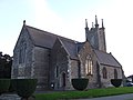
- St. Brigid's, Castleknock, situated in the centre of Castleknock. The building - a listed national monument - was completed in 1870.[5 1] It was rebuilt by a loan of £1000 from the Board of First Fruits and large subscriptions, in 1810. It features a three-stage tower to the west gable with a Gothic tympanum at the entrance and a stained glass window by Harry Clarke that is dedicated to Saint Hubert.
- St. Thomas', Mulhuddart, situated on the Kilbride Road near Hollystown Golf Club. The building - a listed national monument - was constructed in 1870.[5 2] It features a polygonal bell tower in the south corner.
- St. Mary's, Clonsilla, situated at the western end of the Clonsilla Road near Clonsilla railway station. The building - a listed national monument - was constructed in 1846.[5 3] It features stained glass windows by Evie Hone.
In the Catholic Church, the territory of the civil parish is part of the Archdiocese of Dublin. It is currently divided between the following ecclesiastical parishes :
- "Our Lady, Mother of the Church", Castleknock. [2 1][3 2]
- "St. Brigid's", Blanchardstown. [2 2][3 3]
- "St. Thomas, the Apostle", Laurel Lodge / Carpenterstown. [2 3][3 4]
History gallery[]
Church of St. Bridget
in the Church of Ireland, Castleknock
Church of St. Mary
in the Church of Ireland, Clonsilla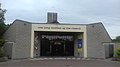
Our Lady Mother of the Church
in the Catholic Church, Castleknock
Church of St. Brigit
in the Catholic Church, Blanchardstown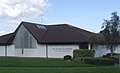
Church of St. Thomas, the Apostle
in the Catholic Church, Laurel Lodge


Location and composition[]
The whole parish is within the Dublin 15 postal district and the territory of Fingal County Council. The core of the parish is centred on the townland and village of the same name. To the north of the parish the Huntstown Power Station and Corduff subsupply station are located. The townland at this northern extremity of the parish is Huntstown, not to be confused with Huntstown and Littlepace in the neighbouring parish of Clonsilla. To the south, it is bounded by the River Liffey and Chapelizod. To the west, it is bounded by the civil parish of Clonsilla which is the location of Blanchardstown Shopping Centre. To the east lies the 8th lock of the Royal Canal in the townland of Pelletstown and the Cabra Gate of the Phoenix Park.
Populated places[]
Populated places in the civil parish include: Blanchardstown, Castleknock, Ashtown, Cabra, Corduff, Laurel Lodge.
Townlands[]
Within the civil parish of Castleknock, there are 22 townlands per the table below. For convenience, the table groups the townlands by their location in one of the modern local authority areas. Some townlands, however, straddle both areas.
| Modern Local Authority Area |
Name in Irish | Name in English | Acres | Image | Commons Category | ||
|---|---|---|---|---|---|---|---|
| Dublin City | Baile an Ásaigh | Ashtown (partly) | 278 | ||||
| Baile Pheiléid | Pelletstown | 259 | |||||
| An Chabrach | Cabra | 457 | |||||
| Caisleán Cnucha (cuid de Pháirc an Fhionnuisce) |
Castleknock (part of Phoenix Park) (partly) |
1020 (787) |
|||||
| Fingal | Baile an Aba | Abbotstown[4 2] | 101 |
| |||
| Baile an Ásaigh | Ashtown (partly)[4 3] | 278 | |||||
| Baile an Chairpintéaraigh | Carpenterstown[4 4] | 166 |  |
| |||
| Baile an Déanaigh | Deanestown[4 5] | 173 |
| ||||
| Baile an Diosualaigh | Diswellstown[4 6] | 418 | |||||
| Baile an Huntaigh | Huntstown[4 7] | 299 | |||||
| Baile an Phóirtéaraigh | Porterstown[4 8] | 219 |
| ||||
| Baile Bhlainséir | Blanchardstown[4 9] | 454 |
| ||||
| Baile Mhistéil | Mitchelstown[4 10] | 154 |  |
||||
| Baile Scriobail | Scribblestown[4 11] | 272 | |||||
| Baile Sheáin | Johnstown[4 12] | 67 | |||||
| An Chabrach | Cabra | 457 | |||||
| Caisleán Cnucha (cuid de Pháirc an Fhionnuisce) |
Castleknock (part of Phoenix Park) (partly) |
1020 (787) |
|||||
| Ceapach | Cappoge or Cappagh | 698 | |||||
| Cnoc na gCaorach | Sheephill | 349 |
| ||||
| An Chorr Dhubh | Corduff | 353 | |||||
| Dún Sinche | Dunsink | 423 |
| ||||
| Páirc Anna | Annfield | 19 |  |
||||
| Snugborough | Snugborough | 53 | |||||
| Steach Gob | Astagob[4 13] | 93 |
Gallery[]

Moorings on the Royal Canal at Ashtown
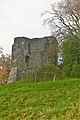
Castleknock Castle

Castleknock Railway Station

Royal Canal at Castleknock

Ringfort or mound at Corduff

Ragwell at Diswellstown

The Diswellstown stream in the glen near Sandpit cottages and Knockmaroon demesne

Observatory at Dunsink


References[]
From "List of Parishes of the Archdiocese of Dublin". Roman Catholic Archdiocese of Dublin. Archdiocese of Dublin. Retrieved 30 December 2020.
From official parish websites
- ^ Church of Ireland - Grouped Parishes of Castleknock and Mulhuddart with Clonsilla
- ^ Catholic Church - Our Lady, Mother of the Church parish
- ^ Catholic Church - St. Brigid's parish
- ^ Catholic Church - St. Thomas the Apostle parish
From "Placenames Database of Ireland". Logainm. Department of Culture, Heritage and the Gaeltacht. Retrieved 30 December 2020.
- ^ "Castleknock civil parish |". logainm.ie. Retrieved 30 December 2020.
- ^ "Abbotstown | logainm.ie". logainm.ie. Retrieved 26 March 2016.
- ^ "Ashtown | logainm.ie". logainm.ie. Retrieved 26 March 2016.
- ^ "Carpenterstown | logainm.ie". logainm.ie. Retrieved 26 March 2016.
- ^ "Deanestown | logainm.ie". logainm.ie. Retrieved 26 March 2016.
- ^ "Diswellstown | logainm.ie". logainm.ie. Retrieved 26 March 2016.
- ^ "Huntstown | logainm.ie". logainm.ie. Retrieved 26 March 2016.
- ^ "Porterstown | logainm.ie". logainm.ie. Retrieved 26 March 2016.
- ^ "Blanchardstown | logainm.ie". logainm.ie. Retrieved 26 March 2016.
- ^ "Mitchelstown | logainm.ie". logainm.ie. Retrieved 26 March 2016.
- ^ "Scribblestown | logainm.ie". logainm.ie. Retrieved 26 March 2016.
- ^ "Johnstown | logainm.ie". logainm.ie. Retrieved 26 March 2016.
- ^ "Astagob | logainm.ie". logainm.ie. Retrieved 18 January 2021.
From "Buildings of Ireland". Search Building & Garden Surveys. National Inventory of Architectural Heritage. Retrieved 30 December 2020.
- ^ Saint Brigid's Church of Ireland Church, Castleknock Road, CASTLEKNOCK (WITHOUT PHOENIX PARK), Castleknock, Fingal - Register number 11362003
- ^ Saint Thomas's Church of Ireland Church, Ratoath Road, HOLLYSTOWN, Fingal - Register number 11346001
- ^ Saint Mary's Church of Ireland Church, CLONSILLA, Clonsilla, Fingal - Register number 11353005
Other sources
- ^ [1] The History of the County of Dublin, John D'Alton, 1838, pg555
- ^ Kidd, Charles, Williamson, David (editors). Debrett's Peerage and Baronetage (1990 edition). New York: St Martin's Press, 1990.
- ^ John Caillard Erck, The ecclesiastical register: containing the names of the dignitaries and parochial clergy of Ireland: as also of the parishes and their respective patrons and an account of monies granted for building churches and glebe-houses with ecclesiastical annals annexed to each diocese and appendixes: containing among other things several cases of quare impedit, (1927), page 113
- ^ Lewis, "Topographical Dictionary of Ireland", 1837
- ^ [2] Samuel Lewis, "A Topographical Dictionary of Ireland", Volume 1, pg 300.
Places in Fingal | |||||||||||||
|---|---|---|---|---|---|---|---|---|---|---|---|---|---|
| Towns and large suburbs |  | ||||||||||||
| Villages and smaller suburbs | |||||||||||||
| Baronies broken out by civil parish (* denotes article not on the civil parish or barony specifically but on the modern district, village or town of the same name) |
| ||||||||||||
Coordinates: 53°22′05″N 6°22′11″W / 53.368010°N 6.369802°W

| Wikimedia Commons has media related to Castleknock (civil parish). |
- Civil parishes of the barony of Castleknock
- Castleknock