Cedar Island (Dukes County, Massachusetts)
 Cedar Island | |
| Geography | |
|---|---|
| Coordinates | 41°30′18″N 70°41′52″W / 41.5051089°N 70.6978079°WCoordinates: 41°30′18″N 70°41′52″W / 41.5051089°N 70.6978079°W[1] |
| Archipelago | Elizabeth Islands |
| Total islands | 1 |
| Administration | |
United States | |
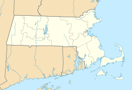
| State | Massachusetts |
| County | Dukes County |


| The Elizabeth Islands |
|---|
 |
| Major islands |
| Minor islands |
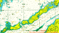
Cedar Island is one of the Elizabeth Islands between Monohansett Island and Nonamesset Island. It is located in Dukes County, Massachusetts, 2.3 miles (3.7 km) southwest of Woods Hole in the Town of Gosnold. The island has been known as Cedar Island due to the profusion of small cedars that grow on it. On 1911 C&GS Charts it is named "East Buck Island".
References[]
- ^ "Cedar Island". Geographic Names Information System. United States Geological Survey. Retrieved 2018-08-20.
This Dukes County, Massachusetts geography–related article is a stub. You can help Wikipedia by . |
Categories:
- Gosnold, Massachusetts
- Coastal islands of Massachusetts
- Elizabeth Islands
- Islands of Dukes County, Massachusetts
- Massachusetts geography stubs