Cedar Park, Philadelphia
Cedar Park | |
|---|---|
 Home in Cedar Park | |
 Cedar Park | |
| Coordinates: Coordinates: 39°56′49″N 75°12′58″W / 39.947°N 75.216°W | |
| Country | |
| State | Pennsylvania |
| County | Philadelphia County |
| City | Philadelphia |
| Area code(s) | 215, 267, and 445 |
Cedar Park is a neighborhood of Philadelphia, Pennsylvania. Located in the larger West Philadelphia district, it stretches north to Larchwood Ave., south to Kingsessing Ave., east to 46th Street, and west to 52nd Street.[1][2]
Originally outlying farmland, Cedar Park was built between 1850 and 1910 as a streetcar suburb[3] of Center City. Its development as a suburb accelerated with the installation of horsecars in the 1850s and again with the arrival of electric trolley lines in 1892.[4]
It is racially and ethnically diverse, and much of the historic Queen Anne-style architecture still stands.
Since about 2000, the neighborhood has been undergoing gentrification stimulated by the University of Pennsylvania's redevelopment plan for West Philadelphia. There is a distinct progressive-politics mien to the neighborhood and a sizable African immigrant community located along and near Baltimore Avenue between 46th and 49th Streets. Cedar Park's residents are predominantly Jamaican/Caribbean and African immigrants, but many are African American (American-born blacks) or white.[citation needed]
Gallery[]
| Wikimedia Commons has media related to Cedar Park, Philadelphia. |
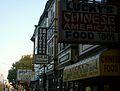
47th Street and Baltimore Ave

Queen Anne-style rooftops
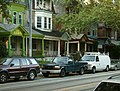
Houses on Baltimore Ave

Rowhouses on 48th Street between Cedar and Walton Streets
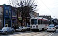
SEPTA'S Route 34 trolley in the 4500 block of Baltimore Avenue


See also[]
External links[]
References[]
- ^ http://www.phila.gov/phils/Docs/otherinfo/pname1.htm
- ^ http://cedarparkneighbors.org/
- ^ West Philadelphia Streetcar Suburb Historic District, UCHS
- ^ "Studio 34's Eponymous Trolley, or, A Short History of Route 34". Studio 34 Yoga. Archived from the original on April 25, 2012. Retrieved May 10, 2012.
- Neighborhoods in Philadelphia
- Streetcar suburbs
- University City, Philadelphia