Central High School Neighborhood Historic District
Central High School Neighborhood Historic District | |
 | |
 | |
| Location | Roughly bounded by MLK Dr., Thayer Ave., W. 12th St., and Roosevelt Rd., Little Rock, Arkansas |
|---|---|
| Coordinates | 34°43′56″N 92°17′43″W / 34.73222°N 92.29528°WCoordinates: 34°43′56″N 92°17′43″W / 34.73222°N 92.29528°W |
| Built | 1870 |
| Architect | multiple |
| Architectural style | Colonial Revival, Bungalow/Craftsman, Tudor Revival |
| NRHP reference No. | 96000892 (original) 96001555 (increase 1) 12000320 (increase 2) |
| Significant dates | |
| Added to NRHP | August 16, 1996[1] |
| Boundary increases | January 17, 1997 June 7, 2012 |


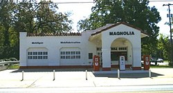
The Central High School Neighborhood Historic District in Little Rock, Arkansas comprises the area surrounding Little Rock Central High School. The area was designated to provide historic context to the National Historic Landmark school. It includes the restored Magnolia Gas Station, which was a staging area for the media during the school integration crisis of 1957. Until the early 21st century, this building served as the National Park Service visitor center for the historic district.[2] Residences in the surrounding area include bungalows, Tudor Revival and Colonial Revival styles.
References[]
- ^ "National Register Information System". National Register of Historic Places. National Park Service. April 15, 2008.
- ^ "Magnolia Gas Station". List of Classified Structures. National Park Service. 2008-11-30. Archived from the original on 2011-05-21. Retrieved 2008-12-01.
This article about a property in Little Rock, Arkansas on the National Register of Historic Places is a stub. You can help Wikipedia by . |
Categories:
- Geography of Little Rock, Arkansas
- Historic districts on the National Register of Historic Places in Arkansas
- Little Rock Central High School
- National Register of Historic Places in Little Rock, Arkansas
- Little Rock, Arkansas Registered Historic Place stubs