Centre of Canada
There are several ways of determining the centre of Canada giving different locations.
Longitude[]
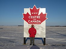
There is a sign on the Trans-Canada Highway at 96°48'35"W (slightly east of Winnipeg) proclaiming it the longitudinal centre of Canada;[1] in effect, the north-south line midway between the extreme points of Canada on the east and west, including islands (including Newfoundland since 1949).
Latitude[]
The latitudinal centre of Canada (including islands, but excluding Canada's claim to the North Pole) is a line at 62 degrees 24 minutes North.
Intersection of latitude and longitude[]
The intersection of these two lines is one definition of the centre point of Canada, as explained by the Atlas of Canada's website:
The centre of Canada can be measured in many ways. The most readily understood would be by taking the mid-point of the extremities of the Canadian landmass section, above. The resulting location 62°24′N 096°28′W / 62.400°N 96.467°W is located just south of Yathkyed Lake in Nunavut, west of Hudson Bay.
 WikiMiniAtlas
The nearest inhabited places to this point are Baker Lake, Nunavut well to the north, and Arviat to the east.
Pole of inaccessibility[]
The pole of inaccessibility of Canada (the point furthest from any coastline or land border) is near , Alberta at 34-115-17-W4 (Latitude: 59°2′ 60 N, Longitude: 112°49′ 60 W). (Pole of inaccessibility says 59 1 48 and 112 49 12.)
References[]
- ^ "Center Of Canada". wikimapia.org.
- ^ "The Atlas of Canada - Frequently Asked Questions About Canada". 22 January 2013. Archived from the original on 2013-01-22.
External links[]
- Geographical centres
- Geography of Canada