Cerro Mesa Ahumada
This article may require copy editing for grammar, style, cohesion, tone, or spelling. (September 2021) |
| Cerro Mesa Ahumada | |
|---|---|
 Cerro Mesa Ahumada | |
| Highest point | |
| Elevation | 2,600 m (8,500 ft) |
| Coordinates | 19°31′58″N 99°07′50″W / 19.53278°N 99.13056°WCoordinates: 19°31′58″N 99°07′50″W / 19.53278°N 99.13056°W |
| Naming | |
| English translation | Mesa Ahumada Hill |
| Language of name | Spanish |
| Geography | |
| Location | Tequixquiac, Apaxco, Huehuetoca; State of Mexico |

This article may be expanded with text translated from the corresponding article in Spanish. (September 2021) Click [show] for important translation instructions.
|
Cerro Mesa Ahumada (Mesa Ahumada Hill) or Cerro Colorado, is a hill located in the northern region of the State of Mexico (Estado de Mexico or Edomex), in Mexico, between the municipalities of Tequixquiac and Apaxco.[1] The hill has a maximum elevation of 2,600 metres (8,500 ft) above sea level,[2] and is located at a southern pass leading out of the Mezquital Valley.
Geology[]
The hill once had natural springs, which have since then dried up. The land is mainly composed of volcanic rock, and the soil is classified as durisol, phaeozem and vertisol.[3]
Archaeological site[]


On the high mesa, there is an archaeological site named Los Mogotes.[4] It was occupied by Otomian-Nahua tribes, and only a few simple pre-Hispanic basements exist on the northwest side of the mesa, along with some petroglyphs on the rocks.[5] The site was discovered in 1984 by locals and is located on the hillside of Cerro Mesa Ahumada at approximately 2,250 metres (7,380 ft) above sea level. when archaeologists from INAH visited this area.[6]
Los Mogotes has 8 basements and a small platform, which correspond to the so-called Coyotlatelco and Mazapa of the late classic or epiclassical period (800-1000 a.C). This site was likely built for military activities for lookouts by Chichimeca people with astronomical observations, funeral activities, and housing. The location has suffered from looting, but items such as obsidian, stone utensils, human bones and mud bows have been found.[7]
The eastern hillsides have petroglyphs, anthropomorphic figures of men and women, the engraving of Tōnatiuh or tonalli, a Nahui Ollin, and concentric cross symbols that probably represent stars or locations.[8] The surroundings of the mesa were used by many nomadic groups, soldiers and merchants, so it was an important location to defend and keep watch because on the mesa the valleys are observed. In Tequixquiac (altepetl) many clashes occurred with Otomis, Aztecs, Tlaxcaltecs, Texcoco and Otumba people, the site on the mesa was necessary for watching people and warriors.[9]
Flora & fauna[]
This section needs additional citations for verification. (September 2021) |
Cerro Mesa Ahumada is in the Central Mexican Plateau, where there is a diversity in plants and animals due to the region's temperate and semi-arid climate.[10][11]
Plants native to the area include: Century plant, cholla, pickly pear, golden barrel cactus, fencepost cactus, billberry cactus, Mexican creeping zinnia, creosote bush, pepicha, creeping false holly, tule, reed, barrel cactus, fern, trees as kidneywood tree, mesquite, netleaf oak, tepozán, needle bush, fruit trees as tejocote, capulin, white sapote and foreign trees as pirul and eucalypt.
Mesa Ahumada has a varied fauna: mammals are cacomistle, skunk, gopher, Virginia opossum, rabbit, Mexican gray squirrel, bat, Mexican hare, birds as turkey, colibri, turkey vulture, northern mockingbird, red warbler, rufous-crowned sparrow, lesser roadrunner, great horned owl, savannah sparrow, reptiles as rattlesnake, pine snake, , chirrionera snake, amphibians as axolotl, frog, toad and insects as red ant, bee, firefly, others. The extinct animals in this mountain since last century are coyote, bobcat and gray fox.
Gallery[]

Tigridia flower.

Cholla (Cardón).

Centuryplant (Maguey).

Barrel cactus (Biznaga).

Fern (Helecho).
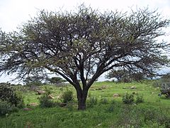
Tree named huizache.
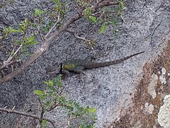
Lizard named .


Sports[]
This nature lands is a landscape used by international sports competitions such as Vuelta Sacra, a mountain bike competition.
Environmental degradation[]

The cause is speculation the authorities of the state government of Mexico on the Cerro Mesa Ahumada prompted former state government through the company Wilk SA.[12] Despite what makes the act has repealed the proposal to create urban development plan because of high speculation was generated by the corruption of the PAN and PRI Tequixquiac and Apaxco mayors before state authorities.
See also[]
References[]
- ^ Díaz, Por Jerónimo (2011-11-22). "Los habitantes de Apaxco en defensa del Cerro Colorado y del bien común • SubVersiones". SubVersiones (in Spanish). Retrieved 2021-09-23.
- ^ "Reforestan el Cerro de la Mesa con especies autóctonas". www.milenio.com (in Spanish). Retrieved 2021-09-23.
- ^ "Archived copy" (PDF). Archived from the original (PDF) on 2016-08-08. Retrieved 2016-05-24.CS1 maint: archived copy as title (link)
- ^ Plan de desarrollo municipal, Tequixquiac Archived 2014-04-30 at the Wayback Machine Page 9, May 22, 2016.
- ^ Rodríguez Peláez, Maria Elena, Monografía municipal de Tequixquiac, Historia, Instituto Mexiquense de Cultura, Toluca de Lerdo, 1999. p.p. 78.
- ^ El sitio arqueológico de Tequixquiac, México. López Warrio, Luis Alberto, Ortuño Cos, Francisco and Pulido Mendez, Salvador. INAH. 1985.
- ^ El sitio arqueológico de Tequixquiac, México. López Warrio, Luis Alberto, Ortuño Cos, Francisco and Pulido Mendez, Salvador. INAH. 1985. pp. 35-38.
- ^ El sitio arqueológico de Tequixquiac, México. López Warrio, Luis Alberto, Ortuño Cos, Francisco and Pulido Mendez, Salvador. INAH. 1985. pp. 39-41.
- ^ Rodríguez Peláez, Maria Elena, Monografía municipal de Tequixquiac, Historia, Instituto Mexiquense de Cultura, Toluca de Lerdo, 1999. p.p. 81.
- ^ Montiel, Rodrigo Cruz (2014-03-03). "Paso Mexiquense". Mi Ambiente (in Spanish). Retrieved 2021-09-23.
- ^ "El cerro de la "mesa ahumada"". dondeescurreelagua.blogspot.mx (in Spanish). Retrieved 2021-09-23.
- ^ [1]
External links[]
| Wikimedia Commons has media related to Cerro Mesa Ahumada. |
- Hills of Mexico
- Landforms of the State of Mexico
- 1984 archaeological discoveries
- Tequixquiac
- Apaxco
- Aztec sites
- Otomi sites