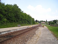
Ceyzériat station
This article needs additional citations for verification. (January 2021) |
 Ceyzériat station in May 2017 | |||||||||||
| Location | Rue de la Gare 01250 Ceyzériat Ain France | ||||||||||
| Elevation | 325 m | ||||||||||
| Owned by | SNCF | ||||||||||
| Operated by | SNCF | ||||||||||
| Line(s) | Bourg-en-Bresse—Bellegarde railway | ||||||||||
| Distance | 9.864 km | ||||||||||
| Platforms | 1 | ||||||||||
| Tracks | 2 | ||||||||||
| History | |||||||||||
| Opened | 10 March 1876 | ||||||||||
| Closed | 2005–2010 (for renovations) | ||||||||||
| Passengers | |||||||||||
| 2019 | 6,762 | ||||||||||
| Services | |||||||||||
| |||||||||||
Ceyzériat station (French: Gare de Ceyzériat) is a French railway station located in commune of Ceyzériat, Ain department in the Auvergne-Rhône-Alpes region. It is located at kilometric point (KP) 9.864 on the Bourg-en-Bresse—Bellegarde railway.
Originally opened in 1876, the station was closed in 2005 for renovations along the Haut-Bugey railway as well as reconstruction of the station, prior to re-opening in 2010.
As of 2020, the station is owned and operated by the SNCF and served by TER Auvergne-Rhône-Alpes trains.
History[]
The station was opened by the on 10 March 1876 along with a section of railway from Bourg-en-Bresse to Simandre-sur-Suran.
The station was closed for reconstruction in 2005, along with the remainder of the line, before re-opening on 12 December 2010. The old passenger building was torn down in June 2010, along with those of and Cize-Bolozon.
In 2019, the SNCF estimated that 6,762 passengers traveled through the station.[1]
Services[]
Passenger services[]
Classified as a PANG (point d'accès non géré), the station is unstaffed without any passenger services.[2]
Train services[]
As of 2020, the station is served by the following services:
- Regional services (TER Auvergne-Rhône-Alpes 31) Bourg-en-Bresse ... Brion-Montréal-la-Cluse ... Oyonnax ... Saint-Claude.[3]
Intermodality[]
The station is equipped with a parking lot for passenger vehicles and secured storage for bicycles.[2]
Gallery[]
- Ceyzériat station image gallery
Ceyzériat station in June 2005, two months prior to closing for reconstruction

Platform after 2005–2010 reconstruction
View from a X 4208 railcar, a couple of days prior to the demolition of the old passenger building

Remnants of the previous passenger building

Old halle à marchandises
References[]
- ^ "Fréquentation en gares - Ceyzériat". ressources.data.sncf.com (in French). Retrieved 6 January 2021.
- ^ Jump up to: a b "TER Auvergne-Rhône-Alpes - Horaires et informations pratiques au départ de la gare de Ceyzériat". www.ter.sncf.com. Retrieved 6 January 2021.
- ^ "31 (MOREZ) ... SAINT-CLAUDE ... OYONNAX .... BOURG-EN-BRESSE ... (LYON)" (PDF). TER Auvergne-Rhône-Alpes.
- Railway stations in Ain


