Chéméré
Chéméré | |
|---|---|
Part of Chaumes-en-Retz | |
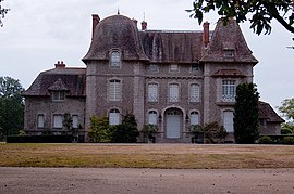 The Château du Bois-Rouaud, in Chéméré | |
 Coat of arms | |
show Location of Chéméré | |
 Chéméré | |
| Coordinates: 47°07′22″N 1°54′49″W / 47.1228°N 1.9136°WCoordinates: 47°07′22″N 1°54′49″W / 47.1228°N 1.9136°W | |
| Country | France |
| Region | Pays de la Loire |
| Department | Loire-Atlantique |
| Arrondissement | Saint-Nazaire |
| Canton | Machecoul |
| Commune | Chaumes-en-Retz |
| Area 1 | 37.31 km2 (14.41 sq mi) |
| Population (2017)[1] | 2,589 |
| • Density | 69/km2 (180/sq mi) |
| Demonym(s) | Chéméréennes, Cheméréens |
| Time zone | UTC+01:00 (CET) |
| • Summer (DST) | UTC+02:00 (CEST) |
| Postal code | 44680 |
| Elevation | 2–60 m (6.6–196.9 ft) |
| Website | http://www.chemere.fr/ |
| 1 French Land Register data, which excludes lakes, ponds, glaciers > 1 km2 (0.386 sq mi or 247 acres) and river estuaries. | |


Chéméré is a former commune in the Loire-Atlantique department in western France. On 1 January 2016, it was merged into the new commune of Chaumes-en-Retz.[2]
See also[]
- Communes of the Loire-Atlantique department
| Wikimedia Commons has media related to Chéméré. |
References[]
| show Authority control |
|---|
This Loire-Atlantique geographical article is a stub. You can help Wikipedia by . |
Categories:
- Former communes of Loire-Atlantique
- Populated places disestablished in 2016
- Loire-Atlantique geography stubs