Chadual
Chadual | |
|---|---|
village | |
 Chadual Location in Rajasthan, India | |
| Coordinates: 24°54′43″N 72°38′49″E / 24.91194°N 72.64694°ECoordinates: 24°54′43″N 72°38′49″E / 24.91194°N 72.64694°E | |
| Country | |
| State | Rajasthan |
| District | Sirohi |
| Government | |
| • Body | Gram Panchayat |
| Languages | |
| • Official | Hindi Marwari |
| Time zone | UTC+5:30 (IST) |
| ISO 3166 code | RJ-IN |
| Vehicle registration | RJ-24 |
| Coastline | 0 kilometres (0 mi) |


Chadual is a village in Sirohi district in the Indian state of Rajasthan
Geography[]
It is located about 25 km west of Sirohi.[1]
Demographics[]
This village has many castes including Purohit, Rawal Brahmin, Rajput, Jain, Suthar, Mali, Prajapat, Bhatt Brahmin, Dewasi, Boda Prajapat, Meghwal and Bheel.
Governance[]
This village is represented by the Rajguru Rajpurohit Brahmin Family (Jagirdar's).
Culture[]
This village has many Hindu temples and also one Jain temple.
Gallery[]
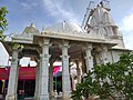
Shri Vaijnath Mahadev Temple in Chadual
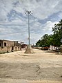
Chadual Bus Station


References[]
- ^ "Pin code Chadual". Pin code india. Retrieved 27 March 2017.
This article related to a location in Rajasthan is a stub. You can help Wikipedia by . |
Categories:
- Villages in Sirohi district
- Rajasthan geography stubs