Changling County
Changling County
长岭县 | |
|---|---|
 Changling in Songyuan | |
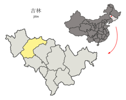 Songyuan in Jilin | |
| Coordinates: 44°16′34″N 123°58′01″E / 44.276°N 123.967°ECoordinates: 44°16′34″N 123°58′01″E / 44.276°N 123.967°E | |
| Country | People's Republic of China |
| Province | Jilin |
| Prefecture-level city | Songyuan |
| Seat | (长岭镇) |
| Area [citation needed] | |
| • Total | 5,787 km2 (2,234 sq mi) |
| Elevation | 191 m (627 ft) |
| Population [citation needed] | |
| • Total | 640,000 |
| • Density | 110/km2 (290/sq mi) |
| Time zone | UTC+8 (China Standard) |
| Postal code | 131500 |

Changling County (simplified Chinese: 长岭县; traditional Chinese: 長嶺縣; pinyin: Chánglǐng Xiàn) is a county in the northwest of Jilin province, China, bordering Inner Mongolia to the west. It is the southernmost and westernmost county-level division of the prefecture-level city of Songyuan, with a population of 640,000[when?] residing in an area of 5,787 km2 (2,234 sq mi).
Administrative divisions[]
The county administers 12 towns and 10 townships.[1]
|
Towns:
|
Townships:
|
Geography and climate[]
Changling is in the southwest part of Songyuan City and borders Nong'an County to the east, Gongzhuling and Shuangliao to the south, Horqin Left Middle Banner of Inner Mongolia to the west, and Tongyu County, Qian'an County, and Qian Gorlos County to the north.
Changling has a monsoon-influenced humid continental climate (Köppen Dwa) characterised by hot, humid summers, due to the monsoon, and long, very cold and dry winters, due to the Siberian anticyclone. A majority of the annual rainfall occurs in July and August. The monthly 24-hour average temperatures ranges from −15.5 °C (4.1 °F) in January to 23.5 °C (74.3 °F) in July, while the annual mean is 5.55 °C (42.0 °F). The frost-free period lasts 140 days.
| hideClimate data for Changling County (1971–2000) | |||||||||||||
|---|---|---|---|---|---|---|---|---|---|---|---|---|---|
| Month | Jan | Feb | Mar | Apr | May | Jun | Jul | Aug | Sep | Oct | Nov | Dec | Year |
| Record high °C (°F) | 5.0 (41.0) |
14.9 (58.8) |
20.4 (68.7) |
29.3 (84.7) |
35.7 (96.3) |
36.5 (97.7) |
36.4 (97.5) |
36.2 (97.2) |
31.2 (88.2) |
27.1 (80.8) |
19.0 (66.2) |
10.6 (51.1) |
36.5 (97.7) |
| Average high °C (°F) | −9.3 (15.3) |
−4.3 (24.3) |
3.9 (39.0) |
14.4 (57.9) |
21.8 (71.2) |
26.6 (79.9) |
28.2 (82.8) |
27.0 (80.6) |
21.6 (70.9) |
13.1 (55.6) |
1.7 (35.1) |
−6.8 (19.8) |
11.5 (52.7) |
| Daily mean °C (°F) | −15.5 (4.1) |
−10.9 (12.4) |
−2.2 (28.0) |
7.9 (46.2) |
15.4 (59.7) |
20.9 (69.6) |
23.5 (74.3) |
21.8 (71.2) |
15.5 (59.9) |
6.7 (44.1) |
−4.0 (24.8) |
−12.5 (9.5) |
5.6 (42.0) |
| Average low °C (°F) | −20.6 (−5.1) |
−16.5 (2.3) |
−8.2 (17.2) |
1.5 (34.7) |
9.0 (48.2) |
15.4 (59.7) |
19.2 (66.6) |
17.2 (63.0) |
9.9 (49.8) |
1.3 (34.3) |
−8.7 (16.3) |
−17.1 (1.2) |
0.2 (32.4) |
| Record low °C (°F) | −33.2 (−27.8) |
−31.5 (−24.7) |
−24.2 (−11.6) |
−12 (10) |
−4.3 (24.3) |
4.4 (39.9) |
10.0 (50.0) |
7.7 (45.9) |
−1.2 (29.8) |
−13.5 (7.7) |
−24.9 (−12.8) |
−32.2 (−26.0) |
−33.2 (−27.8) |
| Average precipitation mm (inches) | 1.6 (0.06) |
2.7 (0.11) |
9.4 (0.37) |
16.3 (0.64) |
40.1 (1.58) |
71.6 (2.82) |
137.3 (5.41) |
97.0 (3.82) |
39.2 (1.54) |
21.8 (0.86) |
6.2 (0.24) |
3.0 (0.12) |
446.2 (17.57) |
| Average precipitation days (≥ 0.1 mm) | 2.4 | 2.8 | 3.8 | 5.6 | 8.4 | 12.0 | 13.4 | 11.0 | 7.9 | 5.1 | 3.8 | 3.4 | 79.6 |
| Source: Weather China | |||||||||||||
References[]
- ^ 2011年统计用区划代码和城乡划分代码:镇赉县 (in Chinese). National Bureau of Statistics of the People's Republic of China. Retrieved 2012-07-17.[permanent dead link]
This Jilin location article is a stub. You can help Wikipedia by . |
- Changling County
- County-level divisions of Jilin
- Jilin geography stubs