Changtai District
Changtai District[1]
长泰区 | |
|---|---|
 Changtai Location of the seat in Fujian | |
| Coordinates: 24°41′N 117°47′E / 24.683°N 117.783°ECoordinates: 24°41′N 117°47′E / 24.683°N 117.783°E | |
| Country | People's Republic of China |
| Province | Fujian |
| Prefecture-level city | Zhangzhou |
| Time zone | UTC+8 (China Standard) |

| Changtai District | |||
|---|---|---|---|
 Maps of "Kien-ning-fou" and "Tchang-tai-hien" from Du Halde's 1735 Description of China, based on Jesuit accounts | |||
| Traditional Chinese | 長泰區 | ||
| Simplified Chinese | 长泰区 | ||
| |||
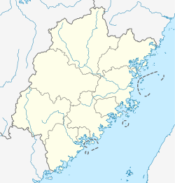
![]() Changtai District (help·info)[1] is a District in Zhangzhou in southern Fujian Province in the People's Republic of China. It is located just outside the Zhangzhou's central urban area.
Changtai District (help·info)[1] is a District in Zhangzhou in southern Fujian Province in the People's Republic of China. It is located just outside the Zhangzhou's central urban area.
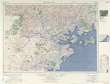
Map including Changtai (labeled as CH'ANG-T'AI 長泰) (1954)
Local Dialect[]
The one and only local dialect of Changtai District is Hokkien, which is spoken with a unique Changtai accent that falls under the Zhangzhou Hokkien accent umbrella, but bears significant differences in pronunciation of certain Chinese characters from the well-known Zhangzhou city accent.
Climate[]
| showClimate data for Changtai (1981−2010) |
|---|
Administrative divisions[]
Towns:[2]
- Wu'an (武安镇), Yanxi (岩溪镇), Chenxiang (陈巷镇), Fangyang (枋洋镇)
The only township is Banli Township (坂里乡)
References[]
- ^ Jump up to: a b "撤县(市)设区 漳州和三明部分行政区划调整". 2021-02-04.
- ^ "漳州市-行政区划网 www.xzqh.org" (in Chinese). XZQH. Retrieved 2012-05-24.
| show Authority control |
|---|
This Fujian location article is a stub. You can help Wikipedia by . |
Categories:
- County-level divisions of Fujian
- Fujian geography stubs