Chappal Waddi
| Chappal Waddi | |
|---|---|
 Adventure to Chappal Waddi | |
| Highest point | |
| Elevation | 2,419 m (7,936 ft)[1] |
| Listing | Country high point |
| Coordinates | 07°02′10″N 11°42′54″E / 7.03611°N 11.71500°ECoordinates: 07°02′10″N 11°42′54″E / 7.03611°N 11.71500°E |
| Geography | |
 Chappal Waddi Location of Chappal Waddi in Nigeria (on border with Cameroon) | |
| Location | Nigeria / Cameroon |

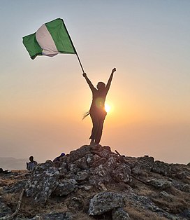
Chappal Waddi is a mountain in Nigeria and, at 2,419 m (7,936 ft), is the country's highest point.[2] It is located in Taraba State, near the border with Cameroon, in the Gashaka Gumti Forest Reserve and Gashaka-Gumti National Park on the Mambilla Plateau.[3] It is a part of the Bamenda-Adamawa-Mandara Mountain chain of Nigeria and Cameroon.
Gallery[]

Chappal Wadi, second highest point in sub-saharan West Africa after Mt Cameroun and Emi Koussi

Dusk in a remote section of Gashaka-Gumti National Park

Boundary along the Nigerian-Cameroun border in Gashaka-Gumti National Park
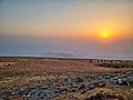
Spectacular sunset on Chappal Waddi

Camping under the stars. The night sky is unpolluted and thus spectacular here.


References[]
- ^ http://www.peakbagger.com/peak.aspx?pid=11096[bare URL]
- ^ http://www.freeworldmaps.net/africa/nigeria/map.html Physical Map of Nigeria
- ^ http://www.nigeria-direct.com/activity/climb-nigeria's-highest-mountain-chappal-waddi[permanent dead link]
This Taraba State, Nigeria location article is a stub. You can help Wikipedia by . |
- Mountains of Nigeria
- Taraba State
- Highest points of countries
- North East Nigeria geography stubs