Charroux, Vienne
Charroux | |
|---|---|
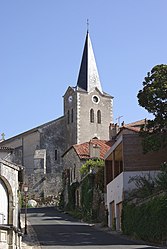 The church of Saint-Sulpice, in Charroux | |
 Coat of arms | |
show Location of Charroux | |
 Charroux | |
| Coordinates: 46°08′43″N 0°24′16″E / 46.1453°N 0.4044°ECoordinates: 46°08′43″N 0°24′16″E / 46.1453°N 0.4044°E | |
| Country | France |
| Region | Nouvelle-Aquitaine |
| Department | Vienne |
| Arrondissement | Châtellerault |
| Canton | Civray |
| Intercommunality | Civraisien en Poitou |
| Government | |
| • Mayor (2020–2026) | Patrice Bosseboeuf |
| Area 1 | 44.29 km2 (17.10 sq mi) |
| Population (Jan. 2018)[1] | 1,137 |
| • Density | 26/km2 (66/sq mi) |
| Time zone | UTC+01:00 (CET) |
| • Summer (DST) | UTC+02:00 (CEST) |
| INSEE/Postal code | 86061 /86250 |
| Elevation | 115–178 m (377–584 ft) (avg. 165 m or 541 ft) |
| 1 French Land Register data, which excludes lakes, ponds, glaciers > 1 km2 (0.386 sq mi or 247 acres) and river estuaries. | |


Charroux (French pronunciation: [ʃaʁu]) is a commune in the Vienne department in the Nouvelle-Aquitaine region in western France.
The remains of the Benedictine Charroux Abbey, founded in the 8th century, are preserved in the town. Said to be the site of the council of Charroux in 989 where the bishops of Aquitaine met to protect the immunity of the clergy and suggested that the church should guarantee that the poor might live in peace.[citation needed]
Demographics[]
| Year | 1962 | 1968 | 1975 | 1982 | 1990 | 1999 | 2006 |
|---|---|---|---|---|---|---|---|
| Population | 1509 | 1621 | 1644 | 1552 | 1428 | 1320 | 1215 |
See also[]
References[]
- ^ "Populations légales 2018". INSEE. 28 December 2020.
| Wikimedia Commons has media related to Charroux, Vienne. |
| show Authority control |
|---|
This Vienne geographical article is a stub. You can help Wikipedia by . |
Categories:
- Communes of Vienne
- Vienne geography stubs