Chaya (Ob)
This article may be expanded with text translated from the corresponding article in Russian. (March 2019) Click [show] for important translation instructions.
|
| Chaya | |
|---|---|
 | |
| Location | |
| Country | Russia |
| Physical characteristics | |
| Mouth | Ob |
• coordinates | 58°16′57″N 82°37′36″E / 58.2826°N 82.6266°ECoordinates: 58°16′57″N 82°37′36″E / 58.2826°N 82.6266°E |
| Length | 194 km (121 mi) |
| Basin size | 27,200 km2 (10,500 sq mi) |
| Basin features | |
| Progression | Ob→ Kara Sea |

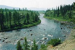
The Chaya (Russian: Чая) is a left tributary of the Ob river in Russia.[1] The river is formed by the confluence of Parbig and rivers. It is located in the Chainsky and Kolpashevsky districts of Tomsk Oblast.
Water Registry Data[]
The Chaya is 194 kilometres (121 mi) long. It flows into the Ob 2,403 km (1,493 mi) from the Ob's mouth. The catchment area is 27,200 square kilometres (10,500 sq mi).[2]
References[]
- ^ Semenova, N (2019). "The unique nature monuments of the Chai River basin (Tomsk oblast, Western Siberia)". Iop Conference Series: Earth and Environmental Science. 232: 012013. doi:10.1088/1755-1315/232/1/012013.
- ^ "Река Чая". Textual.ru. Retrieved March 11, 2019.
This article related to a river in Russia is a stub. You can help Wikipedia by . |
Categories:
- Tributaries of the Ob
- Rivers of Tomsk Oblast
- Russia river stubs