Cherokee County, North Carolina
Cherokee County | |
|---|---|
U.S. county | |
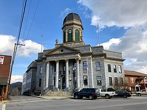 The Cherokee County Courthouse at Murphy | |
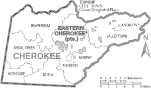
 Location within the U.S. state of North Carolina | |
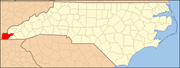
 North Carolina's location within the U.S. | |
| Coordinates: 35°08′N 84°04′W / 35.14°N 84.06°W | |
| Country | |
| State | |
| Founded | 1839 |
| Named for | Cherokee people |
| Seat | Murphy |
| Largest town | Andrews |
| Area | |
| • Total | 467 sq mi (1,210 km2) |
| • Land | 455 sq mi (1,180 km2) |
| • Water | 11 sq mi (30 km2) 2.4%% |
| Population | |
| • Estimate (2019) | 28,612 |
| • Density | 60/sq mi (20/km2) |
| Time zone | UTC−5 (Eastern) |
| • Summer (DST) | UTC−4 (EDT) |
| Congressional district | 11th |
| Website | www |

Cherokee County is the westernmost county in the U.S. state of North Carolina. It borders Tennessee to its west and Georgia to its south. As of the 2010 census, the population was 27,444.[1] The county seat is Murphy, population 1,627 (2010), elevation 1604 ft.[2][3]
History[]
This area was occupied for thousands of years by indigenous peoples who settled in the river valleys. It was part of the historic Cherokee homelands, a large territory composed of areas of what are now western Virginia, western North and South Carolina, eastern Tennessee, and northeastern Georgia.
The county was formed in 1839 from the western part of Macon County in the year that the United States removed most of the Cherokee from the Southeast on what became known as the Trail of Tears. The county was named for the Cherokee Native Americans. It is near the Qualla Boundary, now lands of the federally recognized Eastern Band of Cherokee Indians. This is the only such recognized tribe in North Carolina. The tribe is primarily composed of descendants of Cherokee who remained in North Carolina at the time of removal.
As European-American population increased in the area in the 19th century, the state legislature created new counties. In 1861 the southeastern part of Cherokee County became Clay County. In 1872, its northeastern part was separated and organized as Graham County.
In the late 19th century, there was widespread interest in Native American cultures. In the 1870s, the Valentine brothers of Richmond, Virginia, caused extensive damage to at least eight ancient mounds in Cherokee, Haywood, Jackson, and Swain counties. They roughly excavated and looted them, seeking artifacts for the museum of their father, Mann S. Valentine, which he operated in Richmond.[4]
Geography[]
According to the U.S. Census Bureau, the county has a total area of 467 square miles (1,210 km2), of which 455 square miles (1,180 km2) is land and 11 square miles (28 km2) (2.4%) is water.[5]
Located in the southern Appalachian Mountains, Cherokee County contains a varied natural landscape. Portions of the county fall within the boundaries of the Nantahala National Forest. The Hiwassee River flows into Tennessee after passing through this county from southeast to northwest; it is a tributary of the Tennessee River. Both rivers are known to have had several historic Cherokee towns and villages located along their banks.
In April 1974, parts of Cherokee County were affected by a historic weather event, the 1974 Super Outbreak of tornadoes. This affected parts of 13 states and was the second-largest such event to be recorded in the U.S.
Indian reservation[]
Portions of the Qualla Boundary, also known as the Eastern Cherokee Indian Reservation, are located in Cherokee County. These are non-contiguous and are separate from the main part of the Qualla Boundary, which is in Swain and Jackson counties. The land is exclusive territory of the federally recognized Eastern Band of Cherokee Indians and is protected by their Tribal Police. Following the success of Harrah's Cherokee Tribal Casino in Cherokee, the EBCI opened a second tribal casino in 2015 on a plot of their land here, located within the Murphy city limits.
National protected area[]
- Nantahala National Forest (part)
- Cherokee Indian Reservation, Eastern Band of Cherokee Indians, "patchwork land" (part) that includes an outlying Indian Casino near Andrews, to be operated as part of the main Harrah's Cherokee headquartered in downtown Cherokee. This gaming casino generates revenue used by the EBCI to support education and welfare goals, and economic development.
Adjacent counties[]
- Graham County - north
- Clay County - east
- Macon County - east
- Fannin County, Georgia - south
- Union County, Georgia - south
- Polk County, Tennessee - west
- Monroe County, Tennessee - northwest
Major highways[]
US 64, the longest highway in North Carolina, and a cross-country highway, passes through the county from east–west. US 74, which links Chattanooga, Asheville, Charlotte, and Wilmington, is a major 4-lane highway through the county. US 19 and US 129 also pass through the county, providing connections to Atlanta to the south and Knoxville to the north.
Demographics[]
| Historical population | |||
|---|---|---|---|
| Census | Pop. | %± | |
| 1840 | 3,427 | — | |
| 1850 | 6,838 | 99.5% | |
| 1860 | 9,166 | 34.0% | |
| 1870 | 8,080 | −11.8% | |
| 1880 | 8,182 | 1.3% | |
| 1890 | 9,976 | 21.9% | |
| 1900 | 11,860 | 18.9% | |
| 1910 | 14,136 | 19.2% | |
| 1920 | 15,242 | 7.8% | |
| 1930 | 16,151 | 6.0% | |
| 1940 | 18,813 | 16.5% | |
| 1950 | 18,294 | −2.8% | |
| 1960 | 16,335 | −10.7% | |
| 1970 | 16,330 | 0.0% | |
| 1980 | 18,933 | 15.9% | |
| 1990 | 20,170 | 6.5% | |
| 2000 | 24,298 | 20.5% | |
| 2010 | 27,444 | 12.9% | |
| 2019 (est.) | 28,612 | [6] | 4.3% |
| U.S. Decennial Census[7] 1790-1960[8] 1900-1990[9] 1990-2000[10] 2010-2013[1] | |||
As of the census[11] of 2000, there were 24,298 people, 10,336 households, and 7,369 families residing in the county. The population density was 53 people per square mile (21/km2). There were 13,499 housing units at an average density of 30 per square mile (11/km2). The racial makeup of the county was 94.82% White, 1.59% Black or African American, 1.63% Native American, 0.28% Asian, 0.01% Pacific Islander, 0.45% from other races, and 1.21% from two or more races. 1.25% of the population were Hispanic or Latino of any race. 34.3% were of American, 10.8% Irish, 10.6% German and 10.3% English ancestry according to Census 2000. 97.7% spoke English and 1.2% Spanish as their first language.
There were 10,336 households, out of which 25.60% had children under the age of 18 living with them, 58.80% were married couples living together, 9.30% had a female householder with no husband present, and 28.70% were non-families. 25.70% of all households were made up of individuals, and 12.50% had someone living alone who was 65 years of age or older. The average household size was 2.32 and the average family size was 2.76.
In the county, the population was spread out, with 20.60% under the age of 18, 6.50% from 18 to 24, 24.40% from 25 to 44, 28.80% from 45 to 64, and 19.70% who were 65 years of age or older. The median age was 44 years. For every 100 females there were 94.20 males. For every 100 females age 18 and over, there were 90.70 males.
The median income for a household in the county was $27,992, and the median income for a family was $33,768. Males had a median income of $26,127 versus $18,908 for females. The per capita income for the county was $15,814. About 11.70% of families and 15.30% of the population were below the poverty line, including 19.20% of those under age 18 and 18.00% of those age 65 or over.
Communities[]
Towns[]
Census-designated place[]
Unincorporated communities[]
Townships[]
- Beaverdam
- Hothouse
- Murphy
- Notla
- Shoal Creek
- Valleytown
Government, public safety, and politics[]
Government[]
Mandated by the laws of the State of North Carolina, Cherokee County is governed by an elected five-member Board of Commissioners who each serve a four year term. The Board directs the actions of the appointed Cherokee County Manager.[14]
Public safety[]
Sheriff and police[]
Court protection, jail management, and security for county owned property plus patrol and detective services for unincorporated county areas is provided by the Cherokee County Sheriff. Towns Murphy and Andrews have municipal police departments. The Qualla Boundary tribal police provide security for the Cherokee Nation's Qualla Boundary territories throughout the county.[15][16]
Fire and EMS[]
Fire protection is provided by thirteen all-volunteer fire departments in the county including those at Culberson and Murphy. .[17] Cherokee County Fire Inspector activity is part of the Cherokee County Building Code Enforcement Office.[18]
Politics[]
As is becoming increasingly universal for Appalachia, Cherokee is a powerfully Republican county. No Democratic presidential candidate has carried Cherokee County since Jimmy Carter in 1976, and the past five Republican candidates have all exceeded 65 percent of the county's vote, with Donald Trump exceeding 75 percent.
In the North Carolina House of Representatives, Cherokee County lies with the 120th District, which also covers Clay, Graham and Macon Counties and is represented by Republican Kevin Corbin. In the North Carolina Senate, Cherokee County lies within the 50th Senate District, represented by Republican Senator Jim Davis and covering all those within the 120th House District, as well as Swain, Jackson and Haywood Counties.
Cherokee County is a member of the regional council of governments.
See also[]
References[]
- ^ Jump up to: a b "State & County QuickFacts". United States Census Bureau. Archived from the original on July 8, 2011. Retrieved October 18, 2013.
- ^ https://www.mountaincountrycabinrentals.com/blog/the-history-of-murphy-north-carolina/
- ^ "Find a County". National Association of Counties. Archived from the original on 2015-05-09. Retrieved 2011-06-07.
- ^ Stone, Jessi (3 August 2016). "Protecting the past: Mounds hold key to understanding Cherokee history". Smoky Mountain News. Retrieved 19 December 2020.
- ^ "2010 Census Gazetteer Files". United States Census Bureau. August 22, 2012. Archived from the original on January 12, 2015. Retrieved January 13, 2015.
- ^ "Population and Housing Unit Estimates". Retrieved July 22, 2019.
- ^ "U.S. Decennial Census". United States Census Bureau. Retrieved January 13, 2015.
- ^ "Historical Census Browser". University of Virginia Library. Retrieved January 13, 2015.
- ^ Forstall, Richard L., ed. (March 27, 1995). "Population of Counties by Decennial Census: 1900 to 1990". United States Census Bureau. Retrieved January 13, 2015.
- ^ "Census 2000 PHC-T-4. Ranking Tables for Counties: 1990 and 2000" (PDF). United States Census Bureau. April 2, 2001. Retrieved January 13, 2015.
- ^ "U.S. Census website". United States Census Bureau. Retrieved 2008-01-31.
- ^ Town websites
- ^ "Violet Populated Place Profile / Cherokee County, North Carolina Data". northcarolina.hometownlocator.com.
- ^ https://www.cherokeecounty-nc.gov/
- ^ https://www.cherokeecounty-nc.gov/269/Sheriffs-Office
- ^ http://www.murphypolice.com/
- ^ https://www.cherokeecounty-nc.gov/BusinessDirectoryII.aspx?lngBusinessCategoryID=22
- ^ https://www.cherokeecounty-nc.gov/188/Fire-Inspection-Office
- ^ Leip, David. "Dave Leip's Atlas of U.S. Presidential Elections". uselectionatlas.org. Retrieved 2018-03-15.
External links[]
![]() Media related to Cherokee County, North Carolina at Wikimedia Commons
Media related to Cherokee County, North Carolina at Wikimedia Commons
| show Places adjacent to Cherokee County, North Carolina |
|---|
| show Municipalities and communities of Cherokee County, North Carolina, United States |
|---|


Coordinates: 35°08′N 84°04′W / 35.14°N 84.06°W
| show Authority control |
|---|
- North Carolina counties
- Cherokee County, North Carolina
- Counties of Appalachia
- 1839 establishments in North Carolina
- Populated places established in 1839