Cherry Street lift bridge
Cherry Street lift bridge | |
|---|---|
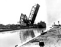
 Cherry Street lift bridge over the Keating Channel in 2008 | |
| Coordinates | 43°38′51″N 79°21′15″W / 43.64750°N 79.35417°WCoordinates: 43°38′51″N 79°21′15″W / 43.64750°N 79.35417°W |
| Carries | vehicular and pedestrian |
| Crosses | Keating Channel |
| Locale | Toronto |
| Owner | City of Toronto |
| Maintained by | Toronto Port Authority |
| Characteristics | |
| Design | Bascule |
| Material | Steel |
| Total length | 29 metres (95.1 ft) |
| Height | 48 metres (157.5 ft) |
| Clearance above | (?) above deck |
| Clearance below | No limit when the bridge is open |
| History | |
| Architect | R. M. Bremner |
| Designer | R. M. Bremner |
| Engineering design by | R. M. Bremner, City of Toronto engineer W. Sefton & Associates, Structural Engineer |
| Constructed by | |
| Construction end | 1968 |
| Location | |
 | |

| Wikimedia Commons has media related to Cherry Street lift bridge. |
The Cherry Street lift bridge over the Keating Channel is the smaller of two bascule lift bridges on Cherry Street, in Toronto, Ontario, Canada. The bridge spans the canalized mouth of the Don River where it empties into Toronto Harbour. It is the fourth bridge at that location.
History[]
The City of Toronto government once operated a swing bridge over the Keating Channel at or near Cherry Street. The current bridge, constructed in 1968, is a vehicle and pedestrian bascule bridge, with a metal mesh deck. The original swing bridge was made of wood, and only carried a single rail line, operated by the Grand Trunk Railway.
The City solicited a bid for the first swing bridge in 1896.[1] Contractors were allowed to propose either a metal or wood bridge. The Privy Council of Canada approved funding of the bridge in 1900.[2] The two spans were 52 feet (15.85 m) long, which was considered sufficient to accommodate navigation on the river." The wooden bridge was replaced by steel draw bridges in 1912 and 1932.[3]
As originally constructed the bridge supported two lanes of traffic in each direction, and had a 1.8-metre (5.9 ft) sidewalk on the west side.[4] In 1995, several changes were made to provide "enhanced safety for cyclists, skaters and pedestrians." As built the entire deck of the bridge, including the sidewalk, was a steel mesh. In 1995 vehicle traffic was restricted to one lane in each direction to make room for a 2-metre (6.6 ft) sidewalk on the east side of the bridge, and the expansion of the sidewalk on the west side to 3.6 metres (12 ft) so it could accommodate bicycles as well as pedestrians. The sidewalks were faced with a non-slip plastic fibreglass surface.
In 2006, an inspection showed that the bridge required CA$2 million in repairs to corrosion damage.[5] The repairs were completed in April 2007. Key bearings in the bridge broke in 2010; it took time for replacement bearings to be found in Sweden.[6] The bridge wasn't restored to working order until June 27, 2011.
On August 1, 2019, the bridge failed to lower. It remained locked in its upright position for several weeks.[7] A crane was used to lower the bridge to the horizontal position. The bridge is currently under repair.[8]
Future[]
The City of Toronto government's long term plans are to "renaturalize" the mouth of the Don River.[9] Under this plan the Keating Channel will be retained, due to its historic value, but a new more natural appearing channel would be constructed south of the Keating Channel.[10]
The current bridge will be replaced by the new Cherry Street North bridges. The pre-fabricated spans for the two side-by-side bridges are expected to be delivered by 2022.[11][12]

Wooden swing bridge over the Keating Channel in 1910.
1912 draw bridge


See also[]
References[]
- ^ "Notice to Contractors: Cherry Street Swing Bridge". Daily Mail and Empire. July 28, 1896. Retrieved March 22, 2012.
- ^
"425q". . 1900.
 Media related to File:Order in Council authorizing the Cherry Street Swing Bridge.jpg at Wikimedia Commons
- ^
"Appendix A: City of Toronto Inventory of Cultural Heritage Properties in Don Mouth Study Area" (PDF). Retrieved May 6, 2020.
Bascule Bridge built in 1968 by City of Toronto’ R. M. Bremner City Engineer; W. Sefton & Associates, Structural Engineer; Ruliff Grass Construction Co. Ltd; operator’s control booth still in place; historical plaque underneath operator booth; concrete substructure of earlier bridge. A wooden draw bridge located over Don Diversion/Keating Channel at Cherry Street in 1899. Current bridge replaced an earlier steel draw bridges in 1912 and 1932.
- ^ Virginia M. West (May 20, 1998). "Cherry Street Bridge - Enhanced Safety for Cyclists, Skaters and Pedestrians". City of Toronto government. Retrieved January 21, 2012.
- ^ "Cherry Street Lift Bridge over the Keating Channel Structural Rehabilitation" (PDF). City of Toronto government. May 15, 2007. Retrieved January 21, 2012.
- ^
Peter Kuitenbrouwer (July 30, 2011). "Old hands keep the Don flowing smoothly". National Post. Postmedia Network. Archived from the original on May 23, 2012. Retrieved January 2, 2012.
The port can haul sludge out of the channel and into the lake only when the Cherry Street lift bridge is in its up position. In 2010, the lift bridge broke and the port could do no dredging at all.
CS1 maint: bot: original URL status unknown (link) - ^ "Frustration mounts as Cherry Street bridge continues to malfunction". CBC News. August 4, 2019. Retrieved August 7, 2019.
- ^ "Cherry Street bridge reopens after being stuck in vertical position for nearly 1 month". globalnews.ca. Global News. August 31, 2019.
- ^ "Lower Don Lands Official Plan Amendments and Keating Channel Precinct West Zoning By-Law – Final Report" (PDF). City of Toronto government. August 11, 2010. Retrieved January 21, 2012.
- ^ "Toronto Port Lands Company – Revitalization Opportunities for the Port Lands – Supplementary Report" (PDF). City of Toronto government. September 21, 2011. Retrieved January 21, 2012.
- ^ McKinley, Steve (October 24, 2020). "Here comes the bridge: A sneak peek at Toronto's new Cherry St. bridge — set to make the trip from Nova Scotia". Toronto Star. Retrieved October 25, 2020.
- ^ Mirabelli, Julian (August 9, 2018). "Eye-Catching Port Lands Bridges in the Works for Villiers Island". UrbanToronto. Retrieved October 25, 2020.
| Crossing the Rouge River | |
|---|---|
| Crossing the Don River |
|
| Pedestrian | |
| Other bridges over waterways | |
| Other | |
- Bridges in Toronto
- Bascule bridges