Chhawani
Chhawani
Chhawani of Amorha State | |
|---|---|
town | |
 Chhawani Location in Uttar Pradesh, India | |
| Coordinates: 26°46′39″N 82°22′47″E / 26.7773679°N 82.3797402°ECoordinates: 26°46′39″N 82°22′47″E / 26.7773679°N 82.3797402°E | |
| Country | |
| State | Uttar Pradesh |
| District | Basti |
| Population (2011) | |
| • Total | 2,000 |
| Languages | |
| • Official | Hindi |
| Time zone | UTC+5:30 (IST) |
| PIN | 272127 |
| Telephone code | 05546 |

Chhawani is a historic place near Amorha in Basti district in the Indian state of Uttar Pradesh. it is also known as a place of freedom struggle of Raja Zalim Singh's State Amorha (also known as Amorha Khas).[1]
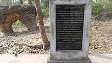
It was the main shelter for Indian fighters during the 1857 mutiny, and is noted for a Pipal tree where about 250 freedom fighter were hanged by the British Government in action after the murder of General Fort.[2]
There is Shaheed Smarak Park in memory of freedom fighters.
Geography[]
Chhawani is located at 26°46′32″N 82°22′42″E / 26.77547°N 82.37839°E.[3]
Also Saheed Smarak Park - Chhawani is located at 26°46′32″N 82°22′42″E / 26.77547°N 82.37839°E.[4]
Demographics[]
As of 2011 India census,[5] Chhawani: is located near Amorha of Basti district in the Indian state of Uttar Pradesh with total of 500 families residing.
Notable places[]
- Amorha Khas is situated at a distance of 41 km from the district headquarters. Its old name is Amorha, It was a province (state) of Raja Zalim Singh in old days. Also Raja Zalim Singh's Mahal is here, Old wall of Mahal is still there with mark of bullet used by English. Also a famous temple Ramrekha Mandir is here. Ramrekha Temple is one of the most ancient Hindu Mandir of Lord Ram & Goddess Sita. Lord Shri Ram was stayed here for one day during His journey of Janakpur-Ayodhya. Lord Shri Rama & Sita with Lakshmana journeyed towards Ayodhya by road called Ram Janki Marg (State Highway 72) near Chhawani.[6][7][8]
- Chhawani is a police station & situated at a distance of 40 km from the district headquarters. It was the main shelter for Indian fighters during the 1857 mutiny, and is noted for a Pipal Trees where about 250 martyrs were hanged by the British Government in action after the murder of General Fort.[9]
- Vikramjot is a Block & small market of Basti district 46 km away from the headquarters of Basti district. The last police station of Basti is there. The Ghaghara River adjoins the market. It is also a block of district it has an electric power station, a hospital with 50 beds, an animal hospital, two inter colleges (Shri Valmiki Inter College mainly), a ganna sumit, a post office and a police station near from village Chhatouna.
- Harraiya is one of the tehsils in Basti district. And there is an Epic story about its name that Lord Ram with Sita and Lakshman Went by this way in Ramayan era. So it was then called as Harirahiya in Awadhi which later turned into Harraiya. It is also a legislative assembly
- Ramrekha Mandir is one of the most ancient Hindu Mandir of Lord Ram and Goddess Sita.
Villages of Block - Vikram Jot[]
- Amorha Khas
- Akla
- Akwara
- Atraura Jham
- Aurangabad
- Babhan Ganwa
- Babhrauli
- Bachhipur
- Basthanwa
- Batauli
- Virpur Kharhara
- Chandra Paliya
- Chapilan
- Chefwa
- Chhitauna
- Daharha Misra
- Deokhal
- Deokher
- Devkali Rani
- Dhaurahra Chauhan
- Dhirauli Babu
- Dhirauli Pandey
- Dubhra Nirwahan
- Gauriya Nain
- Gunda Kunvar
- Harewa Shukul
- Imiliya
- Jaitapur
- Kalani Kala
- Karamiya
- Kenauna
- Keshawapur
- Kewalpur
- Khan Kala - Chhawani
- Khatan Sarai
- Khemraj Pur
- Khesua
- Kunwagaon
- Lajghata
- Madna Majha
- Majhakita Avval
- Majhil Gaon
- Malaheni
- Malauli Dubay
- Malauli Gosain
- Medhayan Shukul
- Medhayen
- Nagra Badli
- Natauwa
- Niyamatpur
- Pachvas
- Phooldih
- Pipari Sangram
- Pure Divaan
- Pure Hemraj
- Rani Gaon
- Rajwapur
- Rikhipur
- Rupgarh
- Sauri
- Savera Lala
- Shankarpur
- Sherwadeeh
- Sikaaha Panday
- Sita Rampur
- Sonbarsa
- Sukrauli Pande
- Tala Gaon
- Tursi
- Vikramjot
Gallery[]

Ramrekha Mandir, Amorha, Basti, Uttar Pradesh, India (रामरेखा मन्दिर - अमोढ़ा)

Sri Ram Janki Hanuman Shiv Durga Mandir, Chhawani, Amorha, Basti, Uttar Pradesh

Sri Ram Janki Hanuman Shiv Durga Mandir, Chhawani, Amorha, Basti, Uttar Pradesh

State Bank of India, Chhawani, Amorha, Basti, Uttar Pradesh


References[]
- ^ "AMODHA KHAS-Gram Panchayat - National Panchayat Portal - Govt. of India". panchayatportals.gov.in. Retrieved 14 January 2017.
- ^ "Archived copy". Archived from the original on 18 December 2012. Retrieved 31 March 2016.CS1 maint: archived copy as title (link)
- ^ "Google maps location of Chhawani". Google maps. Retrieved 1 April 2013.
- ^ "Google maps location of Saheed Smarak Park - Chhawani". Google maps. Retrieved 1 April 2013.
- ^ "Census of India 2001: Data from the 2001 Census, including cities, villages and towns (Provisional)". Census Commission of India. Archived from the original on 16 June 2004. Retrieved 1 November 2008.
- ^ Thomas, D. (1998). Battles and Honours of the Royal Navy. Leo Cooper. p. 16. ISBN 9780850526233. Retrieved 14 January 2017.
- ^ Benett, W.C. (1878). The final settlement report on the Gonda district. 23. p. 22. Retrieved 14 January 2017.
- ^ Michael, B.A. (2014). Statemaking and Territory in South Asia: Lessons from the Anglo–Gorkha War (1814–1816). Anthem Press. p. 151. ISBN 9781783083220. Retrieved 14 January 2017.
- ^ "Tourist%20gen%20info/placeof%20interest". basti.nic.in. Archived from the original on 29 June 2016. Retrieved 14 January 2017.
- Cities and towns in Basti district