Chiloé Province
Chiloé Province
Provincia de Chiloé | |
|---|---|
Province | |
 Seal | |
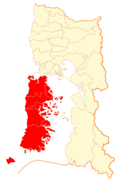 Location in the Los Lagos Region | |
| Coordinates: 42°30′S 74°00′W / 42.500°S 74.000°W | |
| Country | |
| Region | |
| Capital | Castro |
| Communes | show
List of 10: |
| Government | |
| • Type | Provincial |
| • Governor | Fernando Bórquez (RN) |
| Area | |
| • Total | 7,165.5 km2 (2,766.6 sq mi) |
| Population (2012 Census)[1] | |
| • Total | 161,654 |
| • Density | 23/km2 (58/sq mi) |
| • Urban | 82,058 |
| • Rural | 60,136 |
| Sex | |
| • Men | 71,386 |
| • Women | 70,808 |
| Time zone | UTC-4 (CLT[2]) |
| • Summer (DST) | UTC-3 (CLST[3]) |
| Area code(s) | +56-65 |
| Website | www |

Chiloé Province (Spanish: Provincia de Chiloé) is one of the four provinces in the southern Chilean region of Los Lagos (X). It consists of all of Chiloé Archipelago (including Chiloé Island) with the exception of the Desertores Islands. The province spans a surface area of 9,181.6 km2 (3,545 sq mi).[1] Its capital is Castro, and the seat of the Roman Catholic bishopric is Ancud.
Administration[]
As a province, Chiloé is a second-level administrative division of Chile, governed by a provincial governor who is appointed by the president.
Communes[]

The province is composed of ten communes, each governed by a municipality consisting of an alcalde and municipal council.
| Commune | Seal | Population (2017) |
|---|---|---|
| 1. Ancud |  |
38 991 |
| 2. Castro |  |
43 807 |
| 3. Chonchi |  |
14 858 |
| 4. Curaco de Vélez | 3 829 | |
| 5. Dalcahue | 13 762 | |
| 6. Puqueldón | 3 921 | |
| 7. Queilén | 5 385 | |
| 8. Quemchi | 8 352 | |
| 9. Quellón | 27 192 | |
| 10. Quinchao | 8 088 |
Geography and demography[]
According to the 2002 census by the National Statistics Institute (INE), the province spans an area of 7,165.5 km2 (2,767 sq mi) and had a population of 142,194 inhabitants (71,386 men and 70,808 women), giving it a population density of 19.8/km2 (51/sq mi). Of these, 82,058 (57.7%) lived in urban areas and 60,136 (42.3%) in rural areas. Between the 1992 and 2002 censuses, the population grew by 9.1% (11,805 persons).[1]
References[]
- ^ Jump up to: a b c d e "Territorial division of Chile" (PDF) (in Spanish). National Statistics Institute. 2007. Archived from the original (PDF) on 14 November 2010. Retrieved 18 March 2011.
- ^ "Chile Time". WorldTimeZones.org. Archived from the original on 2007-09-11. Retrieved 2010-07-28.
- ^ "Chile Summer Time". WorldTimeZones.org. Archived from the original on 2007-09-11. Retrieved 2010-07-28.

| show Authority control |
|---|
- Chiloé Archipelago
- Provinces of Los Lagos Region
- Provinces of Chile