Chimney Rock (Canada)
| Chimney Rock | |
|---|---|
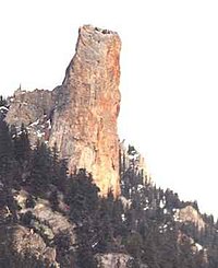 Chimney Rock from the northwest | |
| Highest point | |
| Elevation | 1,725 m (5,659 ft)[1] |
| Prominence | 45 m (148 ft)[1] |
| Listing | Mountains of British Columbia |
| Coordinates | 50°52′42″N 121°43′14″W / 50.87833°N 121.72056°W[1] |
| Geography | |
| Location | British Columbia, Canada |
| Parent range | Marble Range |
| Topo map | NTS 92I13[1] |
| Climbing | |
| First ascent | 1957 Hank Mather; Elfida Pigou[1] |

Chimney Rock (K'lpalekw in Secwepemctsin, meaning "Coyote's Penis") is a limestone formation in Marble Canyon, midway between the towns of Lillooet and Cache Creek in British Columbia, Canada.

Chimney Rock
References[]
External links[]
- "Chimney Rock". Bivouac.com.
This article about a location in the Cariboo Regional District, Canada is a stub. You can help Wikipedia by . |
Categories:
- First Nations culture
- Rock formations of Canada
- Lillooet Country
- Landforms of British Columbia
- Interior Plateau
- Cariboo Regional District geography stubs