Chitrakoot, Madhya Pradesh
Chitrakoot | |
|---|---|
City | |
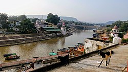 View of ghats at Chitrakoot | |
 Chitrakoot | |
| Coordinates: 25°00′N 80°50′E / 25.00°N 80.83°ECoordinates: 25°00′N 80°50′E / 25.00°N 80.83°E | |
| Country | India |
| State | Madhya Pradesh |
| District | Satna |
| Population (2001) | |
| • Total | 22,294 |
| Languages | |
| • Official | Hindi |
| Time zone | UTC+5:30 (IST) |
| ISO 3166 code | IN-MP |
| Vehicle registration | MP |

Chitrakoot is a pilgrimage centre and a nagar panchayat in the Satna district in the state of Madhya Pradesh, India. Connected to the Indian epic Ramayana, it is a place of religious, cultural, historical and archaeological importance, situated in the Bundelkhand region. It borders the Chitrakoot district in Uttar Pradesh, whose headquarters Chitrakoot Dham is located nearby. The city lies in the historical Chitrakoot region, which is divided between the present-day Indian states of Uttar Pradesh and Madhya Pradesh. It is known for a number of temples and sites mentioned in Hindu scriptures.
It attracts pilgrims throughout the year on occasions such as Amavasya, Somwati Amavasya, Deepawali, Sharad-Poornima, Makar Sankranti, Rama Navami and for Free Eye Care Medical Camps. Noted 'Ayurvedic' and 'Yoga' centres like 'Arogyadham' are located in Chitrakoot.
Legend[]
Chitrakoot is one of the important places connected to the epic Ramayana, where Lord Rama is persuaded by his brother Bharata to return to Ayodhya and where Rama performed the last rites of his father Dasharatha in presence of all the gods and goddesses. The forests of Chitrakoot is where Rama, Sita and Lakshmana took refuge and spent 12 years in the woods, which was already home to several hermits.[1] The ancient Indian sages, including Atri Muni, Rishi Agastya, and Sage Sharbhanga, were said to have meditated in the forests of Chitrakoot.[2]
Geography[]
Chitrakoot means the 'Hill of many wonders'. Chitrakoot region falls in the northern Vindhya Range spread over the states of Uttar Pradesh and Madhya Pradesh. The region is included in the Chitrakoot district of Uttar Pradesh and the Satna district of Madhya Pradesh. Chitrakoot district in Uttar Pradesh was created on 4 September 1998.[3]
Demographics[]
As of the 2011 Census of India Chitrakoot had a population of 23,316. Males constitute 54.36% of the population and females 45.63%, making Female Sex Ratio of 840 against state average of 931. Chitrakoot has an average literacy rate of 70.01%, lower than the national average of 74% and higher than state average 69.32%; with male literacy of 79.49% and female literacy of 58.40%. 15.72% of the population is under 6 years of age.[4]
References[]
| Wikivoyage has a travel guide for Chitrakoot. |
- ^ "Chitrakoot: Mythology Revisited". OutlookIndia.com. Outlook Traveller. 15 May 2017. Retrieved 30 December 2021.
- ^ Mohan, Vineeth (23 April 2018). "Places Connected To Lord Rama And Ramayana - Chitrakoot". NativePlanet.com. Native Planet. Retrieved 30 December 2021.
- ^ District Unit Chitrakoot, National Informatics Centre
- ^ https://censusindia.gov.in/2011census/dchb/2312_PART_B_DCHB_SATNA.pdf
- Cities and towns in Satna district
- Hindu pilgrimage sites in India
- Hindu holy cities
- Ancient Indian cities
- Cities in Bundelkhand
- Places in the Ramayana
- Religion in Madhya Pradesh