Chuckanut Mountains

The Chuckanut Mountains (from "Chuckanut", a native word for "Long beach far from a narrow entrance"[1]), or Chuckanuts, are located on the northern Washington state coast of the Salish Sea, just south of Bellingham, Washington. Being a part of the Cascade Range, they are the only place where the Cascades come west down to meet the sea. The Chuckanuts are considered to be a part of the .
The range contains Larrabee State Park, the first State Park to be designated in Washington (1923). Its mountains include:
- Anderson Mountain
- (including North Chuckanut Mountain, South Chuckanut Mountain, and Chuckanut Ridge)
- Galbraith Mountain (also known as North Lookout Mountain)
- Sehome Hill
Geology[]
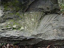
The Chuckanut Mountains were formed by the folding of the Chuckanut Formation (which is predominantly made up of layers of 55-million-year-old sandstone, conglomerate, shale, and bituminous and sub-bituminous coal) and the later (predominantly shale and sandstone) on top, as well as an exposed section of pre-Jurassic-age phyllite.[2] The Chuckanuts are well known for their Tertiary Period leaf fossils.[3]
In 1988, an outcrop of metamorphic phyllite, green chert, and milk quartz on Blanchard Mountain was exposed by a construction crew. The outcrop is unique for its unusually large chunks of stilpnomelane.[4]
References[]
- ^ "Washington Place Names - Search". Archived from the original on 2012-07-13. Retrieved 2007-10-02.
- ^ "BP Cherry Point Cogeneration Project, Application for Site Certification" (PDF). Energy Facility Site Evaluation Council. Archived from the original (PDF) on 2006-09-25. Retrieved 2007-10-02.
- ^ Sykes, Karen (21 March 2001). "Let mind and feet wander at lovely Squires Lake Park". Seattle Post-Intelligencer.
- ^ George E. Mustoe (December 1998). "Stilpnomelane at Blanchard mountain, western Skagit County, Washington". Washington Geology. 26 (4): 3–8.
External links[]
| hide Authority control | |
|---|---|
| General |
|
| National libraries | |
Coordinates: 48°40′44″N 122°28′5″W / 48.67889°N 122.46806°W

This Whatcom County, Washington state location article is a stub. You can help Wikipedia by . |
- Mountain ranges of Washington (state)
- North Cascades of Washington (state)
- Landforms of Whatcom County, Washington
- Whatcom County, Washington geography stubs