Cidacos
This article does not cite any sources. (December 2008) |
| Cidacos River | |
|---|---|
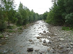 Cidacos river in Arnedo (La Rioja). | |
 Cidacos river location in the Ebro basin | |
| Native name | Río Cidacos (Spanish) |
| Location | |
| Country | Spain |
| Region | Castile and León Soria, La Rioja |
| Physical characteristics | |
| Source | |
| • location | |
| • elevation | 1,425 m (4,675 ft) |
| Mouth | |
• location | Ebro |
• elevation | 290 m (950 ft) |
| Length | 82.8 km (51.4 mi) |
| Basin size | 696 km2 (269 sq mi) |
| Discharge | |
| • average | 2.7 m3/s (95 cu ft/s) |
| Basin features | |
| Progression | Ebro→ Mediterranean Sea |
The Cidacos River is a tributary of the Ebro. Its source is , in Soria, and it flows for 77 km (48 mi) until its reaches the Ebro at Calahorra (La Rioja).
It flows through or past various towns like Villar del Río, Yanguas, Enciso, Peroblasco, Arnedillo, , and Bajera, Herce, Arnedo, Quel, Autol, and Calahorra. The river is used for irrigation purposes and is often dried up near Calahorra.
See also[]
The Cidacos near Autol

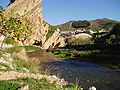
Bridge over the Cidacos near Arnedillo


Coordinates: 42°12′38″N 2°12′21″W / 42.21056°N 2.20583°W

Categories:
- Tributaries of the Ebro
- Rivers of Spain
- Rivers of La Rioja (Spain)
- Rivers of Castile and León
- Spain river stubs