Cima di Jazzi
| Cima di Jazzi | |
|---|---|
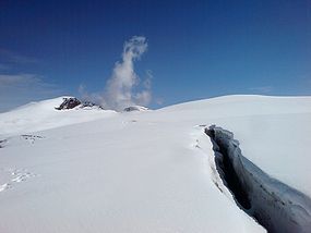 Cima di Jazzi (left) from west | |
| Highest point | |
| Elevation | 3,803 m (12,477 ft) |
| Prominence | 243 m (797 ft)[1] |
| Parent peak | Monte Rosa |
| Coordinates | 45°58′51.9″N 7°53′40.9″E / 45.981083°N 7.894694°ECoordinates: 45°58′51.9″N 7°53′40.9″E / 45.981083°N 7.894694°E |
| Geography | |
 Cima di Jazzi Location in the Alps | |
| Location | Valais, Switzerland Piedmont, Italy |
| Parent range | Pennine Alps |

The Cima di Jazzi (English: Jazzi Peak) is a mountain of the Pennine Alps, located on the Swiss-Italian border, just north of Monte Rosa. It overlooks Macugnaga on its east (Italian) side. The west (Swiss) side is entirely covered by glaciers.
Geography[]
The SOIUSA partition of the Alps places the mountain in the Monte Rosa group of the alpine subsection Eastern Aosta and Northern Valsesia Alps (Pennine Alps); its code is: I/B-9.III-A.3.a.[2]
Mountain huts[]
- Rifugio Eugenio Sella,
- Bivacco Città di Luino,
- Monte Rosa Hütte.
References[]
External links[]
Categories:
- Mountains of the Alps
- Alpine three-thousanders
- Mountains of Piedmont
- Italy–Switzerland border
- International mountains of Europe
- Mountains of Valais
- Mountains of Switzerland